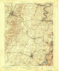
1916 Map of Martinsburg
USGS Topo · Published 1926About this map
Martinsburg and Charles Town anchor this detailed study of the Eastern Panhandle, where the confluence of the Potomac River and Shenandoah River at Harpers Ferry creates a dramatic landscape of deep river bends like Terrapin Neck and Julep Bend. The region's transport network is prominent, featuring the Baltimore and Ohio and Norfolk and Western railroads crossing the fertile valley floor. Beyond the urban centers, the map documents a dense network of early 20th-century rural life, from the County Home near Wiltshire School to numerous country schoolhouses like Eagle School and Fairview School. The land is carved by intricate waterways such as Opequon Creek and Bullskin Run, illustrating the geographic factors that dictated settlement patterns across Berkeley and Jefferson counties before the modern era of highway expansion.
Find a feature on this map
97 named features on this map. Tap any name to fly to it.
Don’t see what you’re looking for? This feature index may not catch every label — zoom into the map to look around manually.
Map Details
Editions of this 1916 Martinsburg Map
4 editions found

Other maps of this area

1884 · Harpers Ferry
USGS Topo · 1:125,000

1891 · Harpers Ferry
USGS Topo · 1:125,000

1893 · Harpers Ferry
USGS Topo · 1:125,000

1894 · Winchester
USGS Topo · 1:125,000

1899 · Hancock
USGS Topo · 1:62,500

1901 · Hancock
USGS Topo · 1:62,500

1908 · Middletown
USGS Topo · 1:48,000

1909 · Hagerstown
USGS Topo · 1:48,000

1910 · Antietam
USGS Topo · 1:62,500

1912 · Hagerstown
USGS Topo · 1:62,500