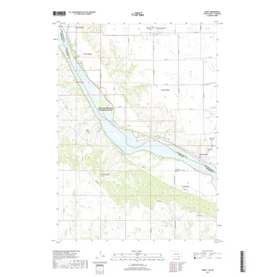
2017 Map of Marty
USGS Topo · Published 2017About this map
The Missouri National Recreation River carves a wide path through this borderland between South Dakota and Nebraska, defining the landscape of Charles Mix and Boyd counties. On the northern banks, the settlement of Marty sits near Saint Pauls Cem, while further downstream, the community of Greenwood serves as a local focal point for genealogy, marked by several burial grounds including Greenwood Presbyterian Cem, Holy Fellowship Cem, and Greenwood Episcopal Cem. The terrain south of the river is characterized by the low-lying Sunshine Bottom and the prominence of Old Baldy, a landmark rising above the river valley. Numerous creeks such as Mosquito Cr and Sevenmile Creek drain into the Missouri, while the Micanek Reservoir provides a managed water source in the southern upland area. The grid of section lines and rural roads like Utopia Rd and Chalk Rock Rd show a highly organized agricultural layout surrounding these riverfront settlements.
Find a feature on this map
48 named features on this map. Tap any name to fly to it.
Don’t see what you’re looking for? This feature index may not catch every label — zoom into the map to look around manually.
Map Details
Editions of this 2017 Marty Map
This is the sole edition of this map. No revisions or reprints were ever made.
Other maps of this area

1950 · Lynch
USGS Topo · 1:24,000

1950 · Monowi
USGS Topo · 1:24,000

1951 · Bristow
USGS Topo · 1:24,000

1952 · Monowi
USGS Topo · 1:24,000

1955 · Mitchell
USGS Topo · 1:250,000

1955 · O'Neill
USGS Topo · 1:250,000

1959 · O'Neill
USGS Topo · 1:250,000

1959 · Mitchell
USGS Topo · 1:250,000

1964 · Fort Randall Dam
USGS Topo · 1:24,000

1964 · Gross
USGS Topo · 1:24,000