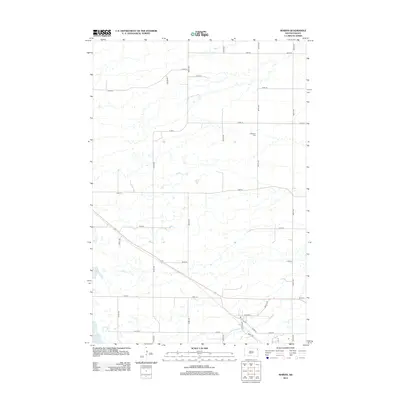
2012 Map of Marvin
USGS Topo · Published 2012About this map
Division St and 1st St anchor the local road network in this section of Grant County, where the landscape is defined by an intricate pattern of glacial wetlands and small water bodies. The small settlement area is oriented along Church St and Marvin Rd, reflecting a grid-based rural development typical of the northeastern South Dakota plains. To the north, the Eastman Cem serves as a significant genealogical landmark, positioned among the section lines of 465th Ave and 141st St. The southwestern corner of the quadrangle is marked by Twin Lakes, while the broader terrain is navigated via a strictly organized system of county routes, including Co Hwy 6 and Co Rd 11. This 2012 survey illustrates how modern infrastructure, such as 466th Ave, integrates with the established hydrology and historical land divisions of the region.
Find a feature on this map
23 named features on this map. Tap any name to fly to it.
Don’t see what you’re looking for? This feature index may not catch every label — zoom into the map to look around manually.
Map Details
Editions of this 2012 Marvin Map
This is the sole edition of this map. No revisions or reprints were ever made.
Other maps of this area

1953 · Milbank
USGS Topo · 1:250,000

1958 · Milbank
USGS Topo · 1:250,000

1970 · Summit
USGS Topo · 1:24,000

1970 · Summit NE
USGS Topo · 1:24,000

1970 · Marvin
USGS Topo · 1:24,000

1970 · Wilmot NW
USGS Topo · 1:24,000

1970 · Still Lake NE
USGS Topo · 1:24,000

1971 · Corona
USGS Topo · 1:24,000
1971 · Wilmot
USGS Topo · 1:24,000

1973 · Twin Brooks
USGS Topo · 1:24,000