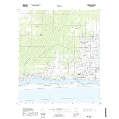
2018 Map of Mary Esther
USGS Topo · Published 2018About this map
Fort Walton Beach and the neighboring settlements of Wright and Mary Esther define the coastal development along the Florida Panhandle in this late-2010s survey. The landscape is dominated by large-scale military installations, specifically the southern reaches of Eglin AFB and the sprawling airfield of Hurlburt Field. These facilities transition into the dense residential grids of the surrounding towns, illustrating the close relationship between the local economy and the aerospace presence. To the south, the Santa Rosa Sound separates the mainland from Santa Rosa Island, where the Gulf Islands National Seashore preserves the barrier island's natural state against the Gulf of Mexico. North of the coastal development, the terrain remains largely untamed, characterized by the East Bay Swamp and various drainage systems such as the E Bay River and Alligator Cr. Local history is anchored by landmarks like the Beal Cem and the North West Florida State College - Ft Walton Beach Campus.
Find a feature on this map
150 named features on this map. Tap any name to fly to it.
Don’t see what you’re looking for? This feature index may not catch every label — zoom into the map to look around manually.
Map Details
Editions of this 2018 Mary Esther Map
This is the sole edition of this map. No revisions or reprints were ever made.
Other maps of this area

1921 · Holley
USGS Topo · 1:62,500

1934 · Holt
USGS Topo · 1:48,000

1934 · Harold
USGS Topo · 1:62,500

1936 · Holley
USGS Topo · 1:48,000

1937 · Holt
USGS Topo · 1:62,500

1937 · Harold
USGS Topo · 1:62,500

1938 · Mary Esther
USGS Topo · 1:62,500

1938 · Holley
USGS Topo · 1:62,500

1938 · Harold
USGS Topo · 1:62,500

1956 · Fort Walton Beach
USGS Topo · 1:62,500