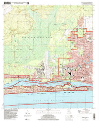
1994 Map of Mary Esther
USGS Topo · Published 1999About this map
Hurlburt Field and the expansive Eglin Air Force Base dominate the western and northern portions of this landscape, reflecting the heavy military footprint on the Florida Panhandle. The residential growth of Wright, Oakland Heights, and Mary Esther is concentrated along the eastern corridor, where suburban development meets the natural boundary of Cinco Bayou. Along the waterfront, the Intracoastal Waterway cuts through the Santa Rosa Sound, separating the mainland from the dunes of Santa Rosa Island. This map documents a period of significant coastal intensification, showing schools like Silver Sands Sch and New Heights Sch alongside local landmarks like the Drive-in Theater. Further inland, the terrain transitions into the low-lying wetlands of East Bay Swamp and the drainages of Alligator Creek and Live Oak Creek.
Find a feature on this map
37 named features on this map. Tap any name to fly to it.
Don’t see what you’re looking for? This feature index may not catch every label — zoom into the map to look around manually.
Map Details
Editions of this 1994 Mary Esther Map
This is the sole edition of this map. No revisions or reprints were ever made.
Other maps of this area

1921 · Holley
USGS Topo · 1:62,500

1934 · Holt
USGS Topo · 1:48,000

1934 · Harold
USGS Topo · 1:62,500

1936 · Holley
USGS Topo · 1:48,000

1937 · Holt
USGS Topo · 1:62,500

1937 · Harold
USGS Topo · 1:62,500

1938 · Mary Esther
USGS Topo · 1:62,500

1938 · Holley
USGS Topo · 1:62,500

1938 · Harold
USGS Topo · 1:62,500

1956 · Fort Walton Beach
USGS Topo · 1:62,500