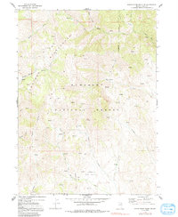
1968 Map of Marys River Basin NE
USGS Topo · Published 1991About this map
Humboldt National Forest encompasses this high-elevation landscape in Elko County, where the Jarbidge Wilderness protects the headwaters of several significant drainages. The Marys River and Wildcat Creek cut through the terrain, fed by numerous unnamed springs and the Right Fork and North Fork of local streams. The presence of the Wildcat Guard Sta suggests the area's importance for forest management and fire lookout duties during the late 1960s.
Find a feature on this map
24 named features on this map. Tap any name to fly to it.
Don’t see what you’re looking for? This feature index may not catch every label — zoom into the map to look around manually.
Map Details
Editions of this 1968 Marys River Basin NE Map
3 editions found
Other maps of this area

1943 · Jarbidge
USGS Topo · 1:62,500

1945 · Jarbidge
USGS Topo · 1:62,500

1955 · Wells
USGS Topo · 1:250,000

1957 · Elk Mountain
USGS Topo · 1:62,500

1958 · Wells
USGS Topo · 1:250,000

1961 · Wells
USGS Topo · 1:250,000

1968 · Charleston Reservoir
USGS Topo · 1:24,000

1968 · Marys River Basin NE
USGS Topo · 1:24,000

1968 · Marys River Basin SE
USGS Topo · 1:24,000

1968 · Hot Creek
USGS Topo · 1:24,000