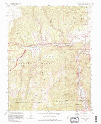
1981 Map of Marysvale Canyon
USGS Topo · Published 1995About this map
Marysvale Canyon serves as the dramatic centerpiece of this early 1980s landscape, where the Sevier River carves a deep path between the Sargent Mountain and the Antelope Range. The map documents a corridor of heavy transit and recreation, featuring the namesake Big Rock Candy Mountain and the sprawling boundaries of Fremont Indian State Park. A clear industrial legacy is visible through an Old Railroad Grade that hugs the riverbank, alongside scattered prospecting sites like the Yellow Cougar Mine and BW and H Mine situated on the rugged eastern slopes.
Find a feature on this map
41 named features on this map. Tap any name to fly to it.
Don’t see what you’re looking for? This feature index may not catch every label — zoom into the map to look around manually.
Map Details
Editions of this 1981 Marysvale Canyon Map
2 editions found
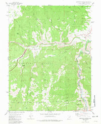
Other maps of this area

1885 · Beaver
USGS Topo · 1:250,000

1932 · Sevier
USGS Topo · 1:62,500

1935 · Sevier
USGS Topo · 1:62,500

1937 · Delano Peak
USGS Topo · 1:48,000

1940 · Monroe
USGS Topo · 1:62,500

1943 · Delano Peak
USGS Topo · 1:62,500

1944 · Monroe
USGS Topo · 1:62,500

1945 · Marysvale
USGS Topo · 1:62,500

1947 · Marysvale
USGS Topo · 1:62,500

1953 · Richfield
USGS Topo · 1:250,000