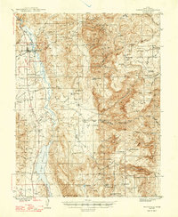
1947 Map of Marysvale
USGS Topo · Published 1947About this map
The Sevier River valley serves as the central corridor for agriculture and industry in this post-war survey of Piute County. The railhead of the Denver & Rio Grande Western terminates at Marysvale, a critical shipping point for the region's mineral wealth. To the south, the massive Piute Reservoir dominates the landscape, providing irrigation for the valley's smaller settlements like Junction and Thompsonville. Evidence of the area's mining history is scattered throughout the eastern slopes, specifically at the Whitehorse Mine and the mining camps of Alunite and Gold. The map illustrates a transitional period where livestock operations, represented by the Elbow Ranch, coexisted with federal land management at the Dry Creek Guard Sta within the Fishlake National Forest. The complex network of irrigation features, including the Pole Canyon Res and Swift Spring, highlights the intensive water management required to sustain this high-altitude desert environment.
Find a feature on this map
60 named features on this map. Tap any name to fly to it.
Don’t see what you’re looking for? This feature index may not catch every label — zoom into the map to look around manually.
Map Details
Editions of this 1947 Marysvale Map
3 editions found

Other maps of this area

1885 · Beaver
USGS Topo · 1:250,000

1885 · Fish Lake
USGS Topo · 1:250,000

1896 · Fish Lake
USGS Topo · 1:250,000

1932 · Sevier
USGS Topo · 1:62,500

1935 · Sevier
USGS Topo · 1:62,500

1937 · Delano Peak
USGS Topo · 1:48,000

1940 · Monroe
USGS Topo · 1:62,500

1943 · Delano Peak
USGS Topo · 1:62,500

1944 · Monroe
USGS Topo · 1:62,500

1945 · Marysvale
USGS Topo · 1:62,500