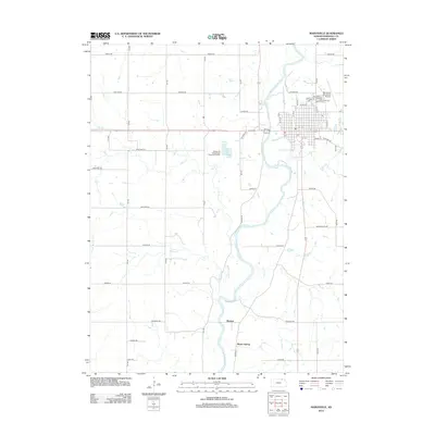
2012 Map of Marysville
USGS Topo · Published 2012About this map
The Big Blue River serves as the central geographic axis for this portion of Marshall County, winding past the county seat. The town of Marysville is shown with a developed grid of streets, including N St and Otoe St, which center around the municipal Po and the local Marysville Cem. Beyond the city limits, the landscape transitions into a network of rural roads such as Indian Rd and Jayhawk Rd that define the agricultural character of the region. To the south, the settlement of Shroyer sits near the riverbanks, while Alcove Spring represents a significant local landmark. This 2012 survey illustrates the modern configuration of regional transport and drainage, tracing several smaller waterways including Dutch Cr, Spring Cr, and Rocky Run as they converge toward the main river valley.
Find a feature on this map
47 named features on this map. Tap any name to fly to it.
Don’t see what you’re looking for? This feature index may not catch every label — zoom into the map to look around manually.
Map Details
Editions of this 2012 Marysville Map
This is the sole edition of this map. No revisions or reprints were ever made.
Other maps of this area

1889 · Marysville
USGS Topo · 1:125,000

1894 · Marysville
USGS Topo · 1:125,000

1955 · Manhattan
USGS Topo · 1:250,000

1956 · Manhattan
USGS Topo · 1:250,000

1957 · Manhattan
USGS Topo · 1:250,000

1966 · Oketo
USGS Topo · 1:24,000

1966 · Marysville
USGS Topo · 1:24,000

1966 · Hanover SE
USGS Topo · 1:24,000
1966 · Herkimer
USGS Topo · 1:24,000

1966 · Home
USGS Topo · 1:24,000