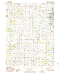
1984 Map of Maryville West
USGS Topo · Published 1985About this map
Maryville serves as the focal point of this Northwest Missouri landscape in the mid-1980s, dominated by the campus of Northwest Missouri State University and its associated infrastructure. The town's western edge is marked by a transition from residential streets to more open terrain, including a large Golf Course and the Memorial Airport. To the south, the Drive-in Theater reflects the car-centric local culture of the era, while the Norfolk and Western railroad line cuts through the northeastern corner, providing a vital industrial link.
Find a feature on this map
23 named features on this map. Tap any name to fly to it.
Don’t see what you’re looking for? This feature index may not catch every label — zoom into the map to look around manually.
Map Details
Editions of this 1984 Maryville West Map
This is the sole edition of this map. No revisions or reprints were ever made.
Other maps of this area

1926 · Maitland
USGS Topo · 1:62,500

1927 · Bolckow
USGS Topo · 1:62,500

1939 · Skidmore
USGS Topo · 1:62,500

1941 · Skidmore
USGS Topo · 1:62,500

1942 · Skidmore
USGS Topo · 1:62,500

1943 · Maryville
USGS Topo · 1:62,500

1945 · Bolckow
USGS Topo · 1:62,500

1955 · Nebraska City
USGS Topo · 1:250,000

1957 · Nebraska City
USGS Topo · 1:250,000

1958 · Nebraska City
USGS Topo · 1:250,000