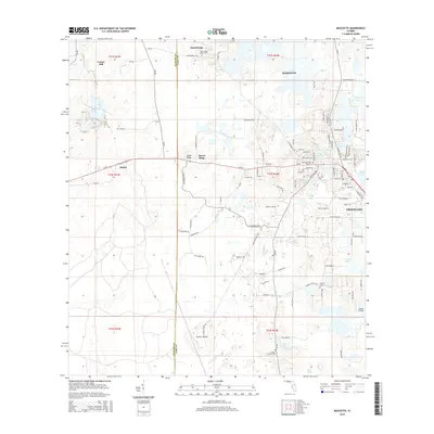
2015 Map of Mascotte
USGS Topo · Published 2015About this map
Mascotte and Groveland anchor the eastern side of this Central Florida landscape, where residential expansion meets a complex hydrologic network. The map reveals a transition from the elevated terrain of Slones Ridge and Carters Island down to the low-lying wetlands and citrus groves characteristic of Lake County. Significant genealogical interest is found in the scattered burial grounds of the region, including the Tuscannoga Baptist Cem, Mascotte Cem, and the small Fender Family Cem located near Twin Lake.
Find a feature on this map
108 named features on this map. Tap any name to fly to it.
Don’t see what you’re looking for? This feature index may not catch every label — zoom into the map to look around manually.
Map Details
Editions of this 2015 Mascotte Map
This is the sole edition of this map. No revisions or reprints were ever made.
Other maps of this area

1955 · Plant City
USGS Topo · 1:250,000

1955 · Orlando
USGS Topo · 1:250,000

1957 · Orlando
USGS Topo · 1:250,000

1958 · Orlando
USGS Topo · 1:250,000

1958 · Plant City
USGS Topo · 1:250,000

1958 · Webster
USGS Topo · 1:24,000

1958 · Bushnell
USGS Topo · 1:24,000

1959 · Plant City
USGS Topo · 1:250,000

1959 · Lake Nellie
USGS Topo · 1:24,000
1960 · Bay Lake
USGS Topo · 1:24,000