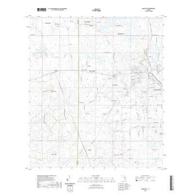
2021 Map of Mascotte
USGS Topo · Published 2021About this map
Mascotte and Groveland stand as primary centers of settlement within a landscape defined by an intricate network of wetlands and lakes along the Lake and Sumter County line. The transition from the dense pine stands of the Withlacoochee State Forest in the west to the open waters of Lake Jackson and Gallows Lake in the east highlights the region's diverse hydrography. The inclusion of the General James A Van Fleet State Trl and the Withlacoochee State Forest Trl indicates how former transportation corridors have been repurposed for modern use. Genealogists will find significant value in the distribution of local burial sites, from the larger Mascotte Cem to the isolated Fender Family Cem. The presence of Osborn Airfield and numerous named islands like Carters Island within the Head Swamp area further characterizes this rural Florida interior during the early 21st century.
Find a feature on this map
123 named features on this map. Tap any name to fly to it.
Don’t see what you’re looking for? This feature index may not catch every label — zoom into the map to look around manually.
Map Details
Editions of this 2021 Mascotte Map
This is the sole edition of this map. No revisions or reprints were ever made.
Other maps of this area

1955 · Plant City
USGS Topo · 1:250,000

1955 · Orlando
USGS Topo · 1:250,000

1957 · Orlando
USGS Topo · 1:250,000

1958 · Orlando
USGS Topo · 1:250,000

1958 · Plant City
USGS Topo · 1:250,000

1958 · Webster
USGS Topo · 1:24,000

1958 · Bushnell
USGS Topo · 1:24,000

1959 · Plant City
USGS Topo · 1:250,000

1959 · Lake Nellie
USGS Topo · 1:24,000
1960 · Bay Lake
USGS Topo · 1:24,000