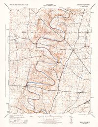
1944 Map of Mason-Dixon
USGS Topo · Published 1944About this map
Conococheague Creek snakes across this 1944 survey, defining the rural borderlands where Franklin Washington meets the Mason and Dixon line. The landscape is a detailed record of mid-century agricultural and early industrial infrastructure, prominently featuring the Fairview Roller Mill and its namesake Fairview Roller Mill Run. Local life at the time centered around small crossroads settlements and one-room schoolhouses like the Sneckerberger School and White Pine School. Further south, the map documents specialized land use at the Cushwa Fish Hatchery and extractive operations at the Wilson Quarry. The winding waterway is peppered with several fords and small clusters such as Broadfording and Hicksville, while the Western Maryland Pennsylvania railroad corridor cuts across the southern portion near Jamison Yard.
Find a feature on this map
37 named features on this map. Tap any name to fly to it.
Don’t see what you’re looking for? This feature index may not catch every label — zoom into the map to look around manually.
Map Details
Editions of this 1944 Mason-Dixon Map
2 editions found
Other maps of this area

1900 · Mercersburg
USGS Topo · 1:62,500

1902 · Chambersburg
USGS Topo · 1:62,500

1902 · Mercersburg
USGS Topo · 1:62,500

1909 · Hagerstown
USGS Topo · 1:48,000

1912 · Hagerstown
USGS Topo · 1:62,500

1912 · Williamsport
USGS Topo · 1:62,500

1942 · Hagerstown
USGS Topo · 1:125,000

1943 · Hagerstown
USGS Topo · 1:125,000

1943 · Mercersburg
USGS Topo · 1:24,000

1943 · Chambersburg
USGS Topo · 1:62,500