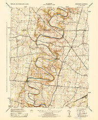
1944 Map of Mason-Dixon
USGS Topo · Published 1944About this map
Conococheague Creek carves a winding, serpentine path through this borderland landscape, defining the topography south of the Mason and Dixon Line. This 1944 War Department survey highlights a region shaped by its water resources and agrarian industry, notably at the Fairview Roller Mill and the Cushwa Fish Hatchery. The map captures a high density of rural institutions such as Sunrise School and Sneckberger School, serving established crossroads like Broadfording and Huyett.
Find a feature on this map
40 named features on this map. Tap any name to fly to it.
Don’t see what you’re looking for? This feature index may not catch every label — zoom into the map to look around manually.
Map Details
Editions of this 1944 Mason-Dixon Map
2 editions found
Other maps of this area

1900 · Mercersburg
USGS Topo · 1:62,500

1902 · Chambersburg
USGS Topo · 1:62,500

1902 · Mercersburg
USGS Topo · 1:62,500

1909 · Hagerstown
USGS Topo · 1:48,000

1912 · Hagerstown
USGS Topo · 1:62,500

1912 · Williamsport
USGS Topo · 1:62,500

1942 · Hagerstown
USGS Topo · 1:125,000

1943 · Hagerstown
USGS Topo · 1:125,000

1943 · Mercersburg
USGS Topo · 1:24,000

1943 · Chambersburg
USGS Topo · 1:62,500