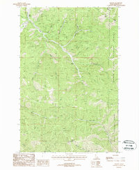
1988 Map of Masonia
USGS Topo · Published 1988About this map
Masonia stands as a focal point in this 1980s landscape, marking a historical settlement location within the high drainage basins of Shoshone County. The terrain is defined by the complex branching of Pine Creek, with its East Fork, West Fork, and numerous smaller tributaries like Nabob Creek and Denver Creek cutting through the mountains. This era of mapping documents a region heavily utilized for resource extraction, evidenced by the numerous unmarked prospect locations scattered across the slopes of Wardner Peak and Kellogg Peak. The area is bisected by the boundary between the Coeur d'Alene National Forest and the St Joe National Forest, emphasizing its role as managed timber and mineral land. High-altitude landmarks such as the Lookout Tower on Lemonade Peak and a Radio Tower near the northeastern peaks overlook a network of logging roads and a Pack Trail that once facilitated movement through these steep Idaho valleys.
Find a feature on this map
28 named features on this map. Tap any name to fly to it.
Don’t see what you’re looking for? This feature index may not catch every label — zoom into the map to look around manually.
Map Details
Editions of this 1988 Masonia Map
This is the sole edition of this map. No revisions or reprints were ever made.
Other maps of this area

1901 · Coeur D'Alene District
USGS Topo · 1:62,500

1903 · Coeur D'Alene District
USGS Topo · 1:62,500

1906 · Coeur D'Alene District
USGS Topo · 1:62,500

1909 · Cataldo
USGS Topo · 1:125,000

1911 · Cataldo
USGS Topo · 1:125,000

1950 · Twin Crags
USGS Topo · 1:24,000

1952 · Twin Crags
USGS Topo · 1:24,000

1955 · Spokane
USGS Topo · 1:250,000

1957 · Kingston
USGS Topo · 1:62,500

1957 · Kellogg
USGS Topo · 1:62,500