
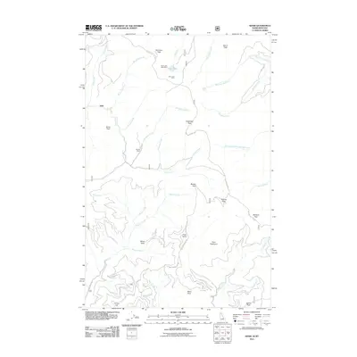
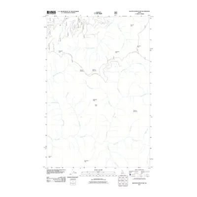
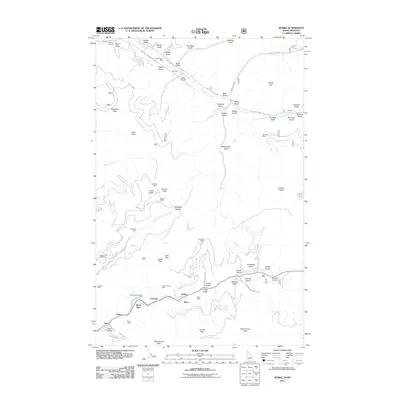
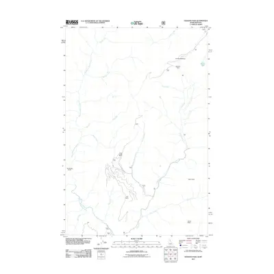
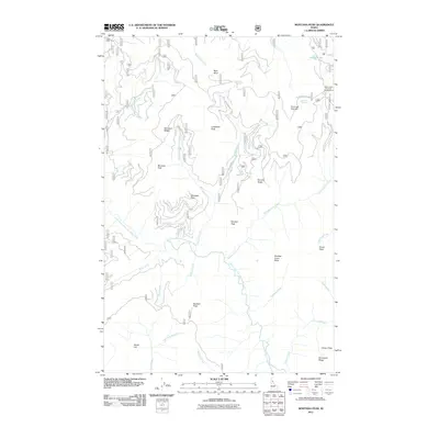
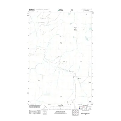
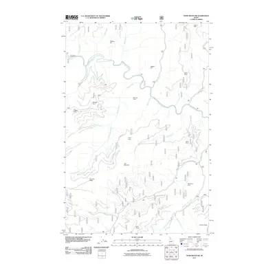
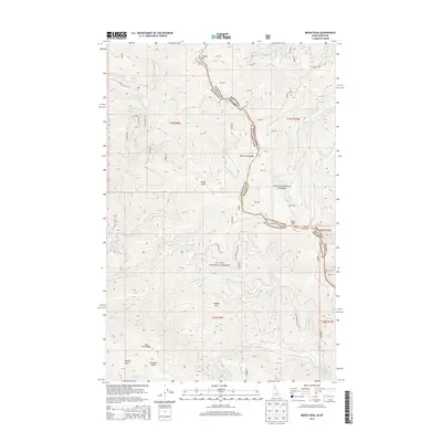
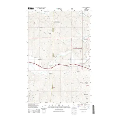
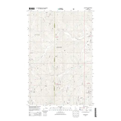
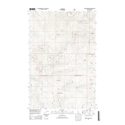
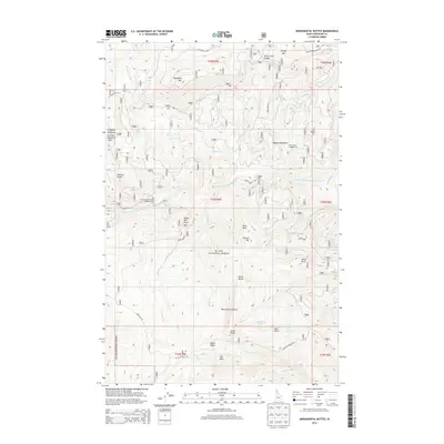
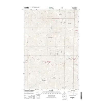
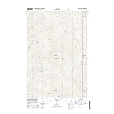
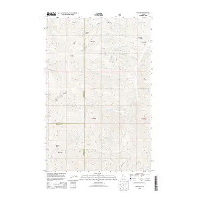
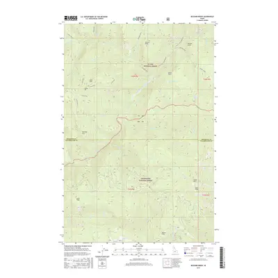
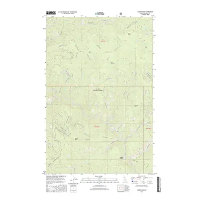
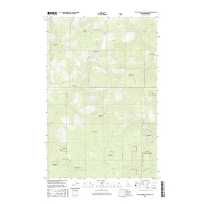
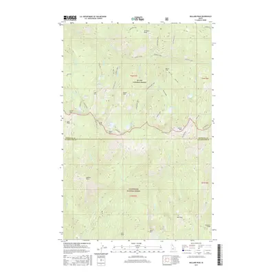
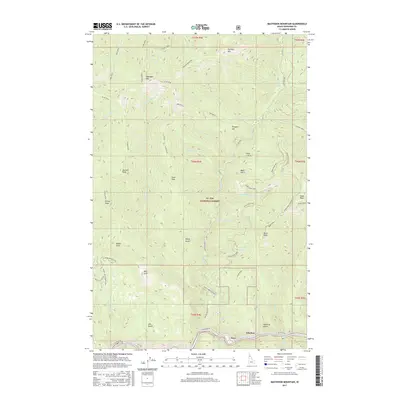
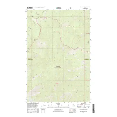
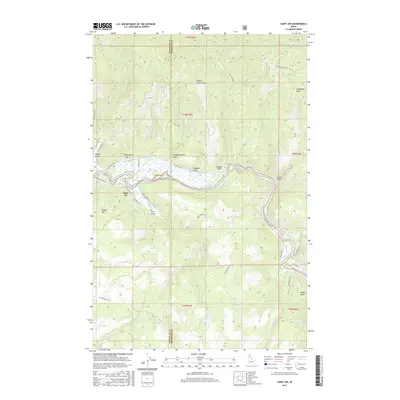
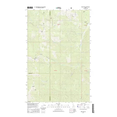
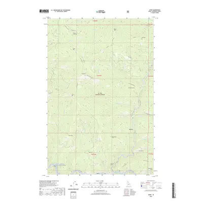
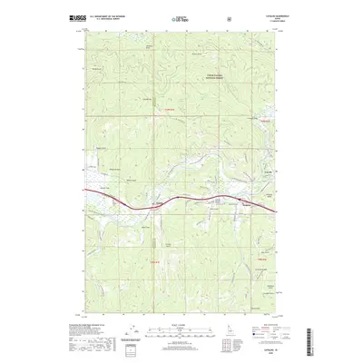
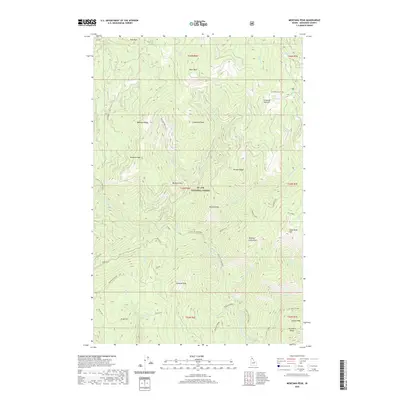
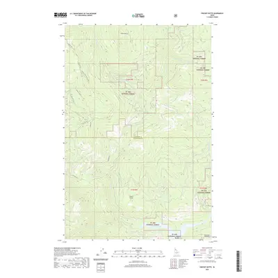
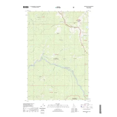
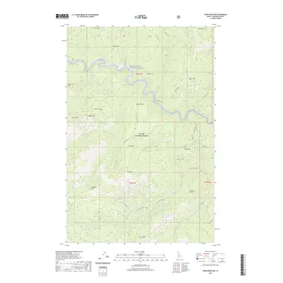
1952 Map of Twin Crags
USGS Topo · Published 1952About this map
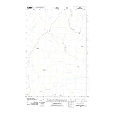
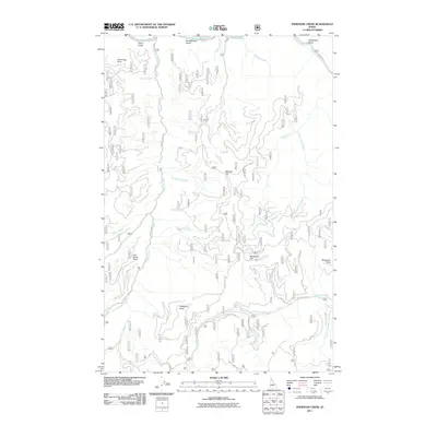
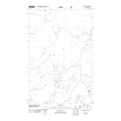
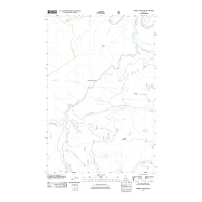
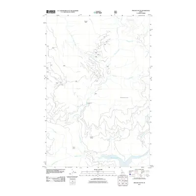
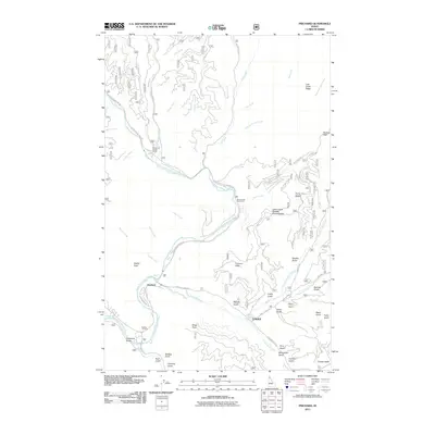
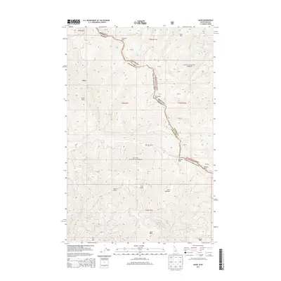
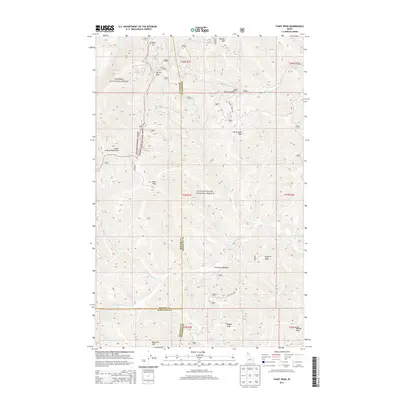
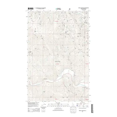
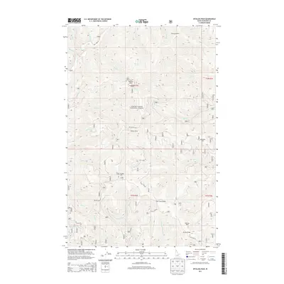
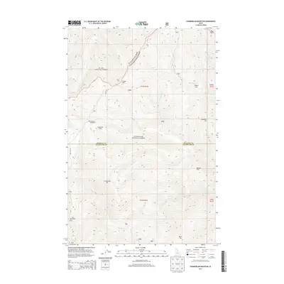
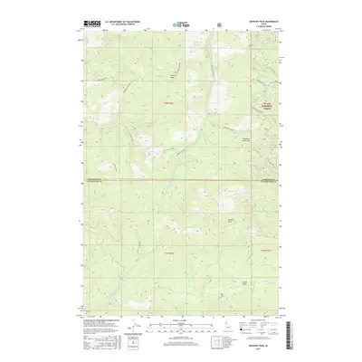
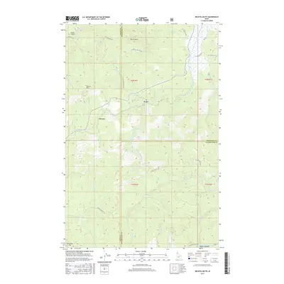
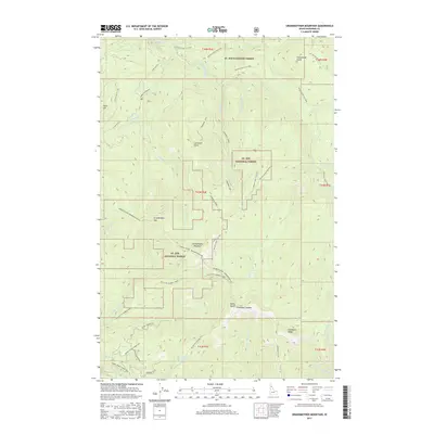
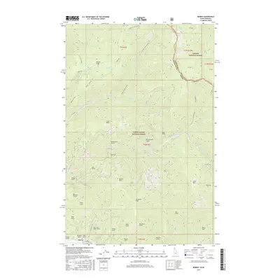
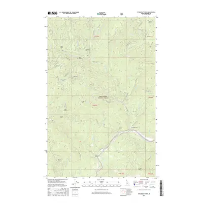
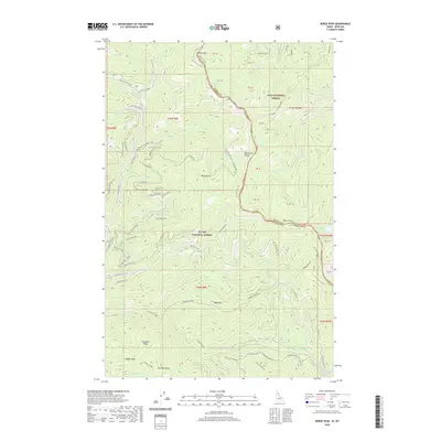
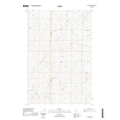
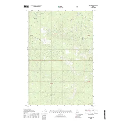
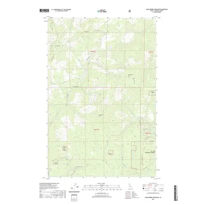
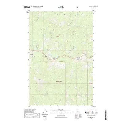
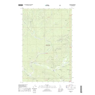
Twin Crags and Mount Wiessner dominate this section of the Idaho panhandle, marking the high country where the Coeur d'Alene National Forest meets the St Joe National Forest. The landscape is defined by the sharp transition across the St Joe Divide, where various drainages like Pine Creek and Jackass Creek carry water north toward the Coeur d'Alene River system. Prospecting and resource extraction are evident in the northern reaches, particularly at the Palisade Mine near Latour Peak and scattered Prospects further east. The proximity of Mirror Lake to these high peaks suggests a geography of high-altitude basins typical of the region's mineral-rich districts. This 1952 edition reflects the area during a period of active timber and mining interest, long before modern wilderness designations reshaped local land use.
Find a feature on this map
31 named features on this map. Tap any name to fly to it.
Don’t see what you’re looking for? This feature index may not catch every label — zoom into the map to look around manually.
Map Details
Editions of this 1952 Twin Crags Map
This is the sole edition of this map. No revisions or reprints were ever made.
Historical Maps of Kootenai County Through Time
399 maps found

1909 Cataldo
Shoshone County, ID

1911 Cataldo
Shoshone County, ID

1914 Avery
Shoshone County, ID

1917 Avery
Shoshone County, ID

1950 Twin Crags
Shoshone County, ID
1952 Twin Crags
Shoshone County, ID

1957 Burke
Shoshone County, ID

1957 Calder
Shoshone County, ID

1957 Simmons Peak
Shoshone County, ID

1963 Bacon Peak
Shoshone County, ID

1963 Buzzard Roost
Shoshone County, ID

1963 Mallard Peak
Shoshone County, ID

1963 Pole Mtn
Shoshone County, ID

1965 Chamberlain Mtn
Shoshone County, ID

1965 Hoodoo Pass
Shoshone County, ID

1966 Cathedral Peak
Shoshone County, ID

1966 Jordan Creek
Shoshone County, ID

1966 Pond Peak
Shoshone County, ID

1966 Spyglass Peak
Shoshone County, ID

1966 Taylor Peak
Shoshone County, ID

1969 Anthony Peak
Shoshone County, ID

1969 Bathtub Mtn
Shoshone County, ID

1969 Fishhook Creek
Shoshone County, ID

1969 Grandmother Mountain
Shoshone County, ID

1969 Grice Ridge
Shoshone County, ID

1969 Hoyt Mountain
Shoshone County, ID

1969 Huckleberry Mtn
Shoshone County, ID

1969 Marble Mtn
Shoshone County, ID

1969 Merry Creek
Shoshone County, ID

1969 Montana Peak
Shoshone County, ID

1969 Monumental Buttes
Shoshone County, ID

1969 Thor Mountain
Shoshone County, ID

1969 Three Sisters
Shoshone County, ID

1969 Widow Mtn
Shoshone County, ID

1981 Little Goat Mountains
Shoshone County, ID

1981 Pinchot Butte
Shoshone County, ID

1985 Bumblebee Peak
Shoshone County, ID

1985 Burke
Shoshone County, ID

1985 Cataldo
Shoshone County, ID

1985 Grizzly Mountain
Shoshone County, ID

1985 Kellogg East
Shoshone County, ID

1985 Kellogg West
Shoshone County, ID

1985 Murray
Shoshone County, ID

1985 Prichard
Shoshone County, ID

1985 Steamboat Creek
Shoshone County, ID

1985 St. Joe
Shoshone County, ID

1988 Adair
Shoshone County, ID

1988 Avery
Shoshone County, ID

1988 Berge Peak
Shoshone County, ID

1988 Calder
Shoshone County, ID

1988 Conrad Peak
Shoshone County, ID

1988 Marble Creek
Shoshone County, ID

1988 Masonia
Shoshone County, ID

1988 Mastodon Mountain
Shoshone County, ID

1988 Peggy Peak
Shoshone County, ID

1988 Polaris Peak
Shoshone County, ID

1988 Red Ives Peak
Shoshone County, ID

1988 Shefoot Mountain
Shoshone County, ID

1988 Sherlock Peak
Shoshone County, ID

1990 Bechtel Butte
Shoshone County, ID

1990 Clarkia
Shoshone County, ID

1990 Crystal Peak
Shoshone County, ID

1990 Faset Peak
Shoshone County, ID

1990 Lamb Peak
Shoshone County, ID

1994 Anthony Peak
Shoshone County, ID

1994 Bacon Peak
Shoshone County, ID

1994 Bechtel Butte
Shoshone County, ID

1994 Buzzard Roost
Shoshone County, ID

1994 Chamberlain Mtn
Shoshone County, ID

1994 Grice Ridge
Shoshone County, ID

1994 Hoodoo Pass
Shoshone County, ID

1994 Mallard Peak
Shoshone County, ID

1994 Pinchot Butte
Shoshone County, ID

1994 Pole Mountain
Shoshone County, ID

1995 Adair
Shoshone County, ID

1995 Avery
Shoshone County, ID

1995 Bathtub Mountain
Shoshone County, ID

1995 Berge Peak
Shoshone County, ID

1995 Calder
Shoshone County, ID

1995 Clarkia
Shoshone County, ID

1995 Conrad Peak
Shoshone County, ID

1995 Crystal Peak
Shoshone County, ID

1995 Fishhook Creek
Shoshone County, ID

1995 Grandmother Mountain
Shoshone County, ID

1995 Hoyt Mountain
Shoshone County, ID

1995 Huckleberry Mountain
Shoshone County, ID

1995 Marble Creek
Shoshone County, ID

1995 Marble Mountain
Shoshone County, ID

1995 Masonia
Shoshone County, ID

1995 Mastodon Mountain
Shoshone County, ID

1995 Merry Creek
Shoshone County, ID

1995 Montana Peak
Shoshone County, ID

1995 Monumental Buttes
Shoshone County, ID

1995 Peggy Peak
Shoshone County, ID

1995 Red Ives Peak
Shoshone County, ID

1995 Shefoot Mountain
Shoshone County, ID

1995 Sherlock Peak
Shoshone County, ID

1995 St. Joe
Shoshone County, ID

1995 Thor Mountain
Shoshone County, ID

1995 Three Sisters
Shoshone County, ID

1995 Widow Mountain
Shoshone County, ID

1996 Bumblebee Peak
Shoshone County, ID

1996 Burke
Shoshone County, ID

1996 Cataldo
Shoshone County, ID

1996 Cathedral Peak
Shoshone County, ID

1996 Faset Peak
Shoshone County, ID

1996 Grizzly Mountain
Shoshone County, ID

1996 Jordan Creek
Shoshone County, ID

1996 Kellogg East
Shoshone County, ID

1996 Kellogg West
Shoshone County, ID

1996 Lamb Peak
Shoshone County, ID

1996 Murray
Shoshone County, ID

1996 Polaris Peak
Shoshone County, ID

1996 Pond Peak
Shoshone County, ID

1996 Prichard
Shoshone County, ID

1996 Spyglass Peak
Shoshone County, ID

1996 Steamboat Creek
Shoshone County, ID

1996 Taylor Peak
Shoshone County, ID

1996 Twin Crags
Shoshone County, ID
2011 Adair
Shoshone County, ID
2011 Anthony Peak
Shoshone County, ID
2011 Avery
Shoshone County, ID
2011 Bacon Peak
Shoshone County, ID
2011 Bathtub Mountain
Shoshone County, ID
2011 Bechtel Butte
Shoshone County, ID
2011 Berge Peak
Shoshone County, ID
2011 Bumblebee Peak
Shoshone County, ID
2011 Burke
Shoshone County, ID
2011 Buzzard Roost
Shoshone County, ID

2011 Calder
Shoshone County, ID
2011 Cataldo
Shoshone County, ID
2011 Cathedral Peak
Shoshone County, ID
2011 Chamberlain Mountain
Shoshone County, ID

2011 Clarkia
Shoshone County, ID
2011 Conrad Peak
Shoshone County, ID
2011 Crystal Peak
Shoshone County, ID
2011 Faset Peak
Shoshone County, ID
2011 Fishhook Creek
Shoshone County, ID
2011 Grandmother Mountain
Shoshone County, ID
2011 Grice Ridge
Shoshone County, ID
2011 Grizzly Mountain
Shoshone County, ID
2011 Hoodoo Pass
Shoshone County, ID
2011 Hoyt Mountain
Shoshone County, ID
2011 Huckleberry Mountain
Shoshone County, ID
2011 Jordan Creek
Shoshone County, ID

2011 Kellogg East
Shoshone County, ID

2011 Kellogg West
Shoshone County, ID
2011 Lamb Peak
Shoshone County, ID
2011 Little Goat Mountains
Shoshone County, ID
2011 Mallard Peak
Shoshone County, ID
2011 Marble Creek
Shoshone County, ID
2011 Marble Mountain
Shoshone County, ID
2011 Masonia
Shoshone County, ID
2011 Mastodon Mountain
Shoshone County, ID
2011 Merry Creek
Shoshone County, ID
2011 Montana Peak
Shoshone County, ID
2011 Monumental Buttes
Shoshone County, ID
2011 Murray
Shoshone County, ID
2011 Peggy Peak
Shoshone County, ID
2011 Pinchot Butte
Shoshone County, ID
2011 Polaris Peak
Shoshone County, ID
2011 Pole Mountain
Shoshone County, ID
2011 Pond Peak
Shoshone County, ID
2011 Prichard
Shoshone County, ID
2011 Red Ives Peak
Shoshone County, ID
2011 Saint Joe
Shoshone County, ID
2011 Shefoot Mountain
Shoshone County, ID
2011 Sherlock Peak
Shoshone County, ID
2011 Spyglass Peak
Shoshone County, ID
2011 Steamboat Creek
Shoshone County, ID
2011 Taylor Peak
Shoshone County, ID
2011 Thor Mountain
Shoshone County, ID
2011 Three Sisters
Shoshone County, ID
2011 Twin Crags
Shoshone County, ID
2011 Widow Mountain
Shoshone County, ID
2013 Adair
Shoshone County, ID
2013 Anthony Peak
Shoshone County, ID
2013 Avery
Shoshone County, ID
2013 Bathtub Mountain
Shoshone County, ID
2013 Berge Peak
Shoshone County, ID
2013 Bumblebee Peak
Shoshone County, ID
2013 Burke
Shoshone County, ID
2013 Buzzard Roost
Shoshone County, ID

2013 Calder
Shoshone County, ID
2013 Cataldo
Shoshone County, ID
2013 Cathedral Peak
Shoshone County, ID

2013 Clarkia
Shoshone County, ID
2013 Conrad Peak
Shoshone County, ID
2013 Crystal Peak
Shoshone County, ID
2013 Faset Peak
Shoshone County, ID
2013 Fishhook Creek
Shoshone County, ID
2013 Grandmother Mountain
Shoshone County, ID
2013 Grice Ridge
Shoshone County, ID
2013 Grizzly Mountain
Shoshone County, ID

2013 Hoodoo Pass
Shoshone County, ID
2013 Hoyt Mountain
Shoshone County, ID
2013 Huckleberry Mountain
Shoshone County, ID
2013 Jordan Creek
Shoshone County, ID
2013 Lamb Peak
Shoshone County, ID
2013 Little Goat Mountains
Shoshone County, ID
2013 Mallard Peak
Shoshone County, ID
2013 Marble Creek
Shoshone County, ID
2013 Marble Mountain
Shoshone County, ID
2013 Mastodon Mountain
Shoshone County, ID
2013 Merry Creek
Shoshone County, ID
2013 Montana Peak
Shoshone County, ID
2013 Monumental Buttes
Shoshone County, ID
2013 Murray
Shoshone County, ID
2013 Peggy Peak
Shoshone County, ID
2013 Pinchot Butte
Shoshone County, ID
2013 Polaris Peak
Shoshone County, ID
2013 Pole Mountain
Shoshone County, ID
2013 Pond Peak
Shoshone County, ID
2013 Prichard
Shoshone County, ID
2013 Red Ives Peak
Shoshone County, ID
2013 Saint Joe
Shoshone County, ID
2013 Shefoot Mountain
Shoshone County, ID
2013 Sherlock Peak
Shoshone County, ID
2013 Spyglass Peak
Shoshone County, ID
2013 Taylor Peak
Shoshone County, ID
2013 Thor Mountain
Shoshone County, ID
2013 Three Sisters
Shoshone County, ID
2013 Twin Crags
Shoshone County, ID
2013 Widow Mountain
Shoshone County, ID
2014 Bacon Peak
Shoshone County, ID
2014 Bechtel Butte
Shoshone County, ID
2014 Chamberlain Mountain
Shoshone County, ID

2014 Kellogg East
Shoshone County, ID

2014 Kellogg West
Shoshone County, ID
2014 Masonia
Shoshone County, ID
2014 Steamboat Creek
Shoshone County, ID
2017 Adair
Shoshone County, ID
2017 Anthony Peak
Shoshone County, ID
2017 Avery
Shoshone County, ID
2017 Bacon Peak
Shoshone County, ID
2017 Bathtub Mountain
Shoshone County, ID
2017 Bechtel Butte
Shoshone County, ID
2017 Berge Peak
Shoshone County, ID
2017 Bumblebee Peak
Shoshone County, ID
2017 Burke
Shoshone County, ID
2017 Buzzard Roost
Shoshone County, ID

2017 Calder
Shoshone County, ID
2017 Cataldo
Shoshone County, ID
2017 Cathedral Peak
Shoshone County, ID
2017 Chamberlain Mountain
Shoshone County, ID

2017 Clarkia
Shoshone County, ID
2017 Conrad Peak
Shoshone County, ID
2017 Crystal Peak
Shoshone County, ID
2017 Faset Peak
Shoshone County, ID
2017 Fishhook Creek
Shoshone County, ID
2017 Grandmother Mountain
Shoshone County, ID
2017 Grice Ridge
Shoshone County, ID

2017 Grizzly Mountain
Shoshone County, ID
2017 Hoodoo Pass
Shoshone County, ID
2017 Hoyt Mountain
Shoshone County, ID
2017 Huckleberry Mountain
Shoshone County, ID
2017 Jordan Creek
Shoshone County, ID

2017 Kellogg East
Shoshone County, ID

2017 Kellogg West
Shoshone County, ID
2017 Lamb Peak
Shoshone County, ID
2017 Little Goat Mountains
Shoshone County, ID
2017 Mallard Peak
Shoshone County, ID
2017 Marble Creek
Shoshone County, ID
2017 Marble Mountain
Shoshone County, ID
2017 Masonia
Shoshone County, ID
2017 Mastodon Mountain
Shoshone County, ID
2017 Merry Creek
Shoshone County, ID
2017 Montana Peak
Shoshone County, ID
2017 Monumental Buttes
Shoshone County, ID
2017 Murray
Shoshone County, ID
2017 Peggy Peak
Shoshone County, ID
2017 Pinchot Butte
Shoshone County, ID
2017 Polaris Peak
Shoshone County, ID
2017 Pole Mountain
Shoshone County, ID
2017 Pond Peak
Shoshone County, ID
2017 Prichard
Shoshone County, ID
2017 Red Ives Peak
Shoshone County, ID
2017 Saint Joe
Shoshone County, ID
2017 Shefoot Mountain
Shoshone County, ID
2017 Sherlock Peak
Shoshone County, ID
2017 Spyglass Peak
Shoshone County, ID
2017 Steamboat Creek
Shoshone County, ID
2017 Taylor Peak
Shoshone County, ID
2017 Thor Mountain
Shoshone County, ID
2017 Three Sisters
Shoshone County, ID
2017 Twin Crags
Shoshone County, ID
2017 Widow Mountain
Shoshone County, ID
2020 Adair
Shoshone County, ID
2020 Anthony Peak
Shoshone County, ID
2020 Avery
Shoshone County, ID
2020 Bacon Peak
Shoshone County, ID
2020 Bathtub Mountain
Shoshone County, ID
2020 Bechtel Butte
Shoshone County, ID
2020 Berge Peak
Shoshone County, ID
2020 Bumblebee Peak
Shoshone County, ID
2020 Burke
Shoshone County, ID
2020 Buzzard Roost
Shoshone County, ID

2020 Calder
Shoshone County, ID
2020 Cataldo
Shoshone County, ID
2020 Cathedral Peak
Shoshone County, ID
2020 Chamberlain Mountain
Shoshone County, ID

2020 Clarkia
Shoshone County, ID
2020 Conrad Peak
Shoshone County, ID
2020 Crystal Peak
Shoshone County, ID
2020 Faset Peak
Shoshone County, ID
2020 Fishhook Creek
Shoshone County, ID
2020 Grandmother Mountain
Shoshone County, ID
2020 Grice Ridge
Shoshone County, ID
2020 Grizzly Mountain
Shoshone County, ID
2020 Hoodoo Pass
Shoshone County, ID
2020 Hoyt Mountain
Shoshone County, ID
2020 Huckleberry Mountain
Shoshone County, ID
2020 Jordan Creek
Shoshone County, ID

2020 Kellogg East
Shoshone County, ID

2020 Kellogg West
Shoshone County, ID
2020 Lamb Peak
Shoshone County, ID
2020 Little Goat Mountains
Shoshone County, ID
2020 Mallard Peak
Shoshone County, ID

2020 Marble Creek
Shoshone County, ID

2020 Marble Mountain
Shoshone County, ID
2020 Masonia
Shoshone County, ID
2020 Mastodon Mountain
Shoshone County, ID
2020 Merry Creek
Shoshone County, ID
2020 Montana Peak
Shoshone County, ID
2020 Monumental Buttes
Shoshone County, ID
2020 Murray
Shoshone County, ID
2020 Peggy Peak
Shoshone County, ID
2020 Pinchot Butte
Shoshone County, ID
2020 Polaris Peak
Shoshone County, ID
2020 Pole Mountain
Shoshone County, ID
2020 Pond Peak
Shoshone County, ID
2020 Prichard
Shoshone County, ID
2020 Red Ives Peak
Shoshone County, ID
2020 Saint Joe
Shoshone County, ID
2020 Shefoot Mountain
Shoshone County, ID
2020 Sherlock Peak
Shoshone County, ID
2020 Spyglass Peak
Shoshone County, ID
2020 Steamboat Creek
Shoshone County, ID
2020 Taylor Peak
Shoshone County, ID
2020 Thor Mountain
Shoshone County, ID
2020 Three Sisters
Shoshone County, ID
2020 Twin Crags
Shoshone County, ID
2020 Widow Mountain
Shoshone County, ID

2024 Adair
Shoshone County, ID

2024 Anthony Peak
Shoshone County, ID

2024 Avery
Shoshone County, ID

2024 Bacon Peak
Shoshone County, ID

2024 Bathtub Mountain
Shoshone County, ID

2024 Bechtel Butte
Shoshone County, ID

2024 Berge Peak
Shoshone County, ID

2024 Bumblebee Peak
Shoshone County, ID

2024 Burke
Shoshone County, ID

2024 Buzzard Roost
Shoshone County, ID

2024 Calder
Shoshone County, ID

2024 Cataldo
Shoshone County, ID

2024 Cathedral Peak
Shoshone County, ID

2024 Chamberlain Mountain
Shoshone County, ID

2024 Clarkia
Shoshone County, ID

2024 Conrad Peak
Shoshone County, ID

2024 Crystal Peak
Shoshone County, ID

2024 Faset Peak
Shoshone County, ID

2024 Fishhook Creek
Shoshone County, ID

2024 Grandmother Mountain
Shoshone County, ID

2024 Grice Ridge
Shoshone County, ID

2024 Grizzly Mountain
Shoshone County, ID

2024 Hoodoo Pass
Shoshone County, ID

2024 Hoyt Mountain
Shoshone County, ID

2024 Huckleberry Mountain
Shoshone County, ID

2024 Jordan Creek
Shoshone County, ID

2024 Kellogg East
Shoshone County, ID

2024 Kellogg West
Shoshone County, ID

2024 Lamb Peak
Shoshone County, ID

2024 Little Goat Mountains
Shoshone County, ID

2024 Mallard Peak
Shoshone County, ID

2024 Marble Creek
Shoshone County, ID

2024 Marble Mountain
Shoshone County, ID

2024 Masonia
Shoshone County, ID

2024 Mastodon Mountain
Shoshone County, ID

2024 Merry Creek
Shoshone County, ID

2024 Montana Peak
Shoshone County, ID

2024 Monumental Buttes
Shoshone County, ID

2024 Murray
Shoshone County, ID

2024 Peggy Peak
Shoshone County, ID

2024 Pinchot Butte
Shoshone County, ID

2024 Polaris Peak
Shoshone County, ID

2024 Pole Mountain
Shoshone County, ID

2024 Pond Peak
Shoshone County, ID

2024 Prichard
Shoshone County, ID

2024 Red Ives Peak
Shoshone County, ID

2024 Saint Joe
Shoshone County, ID

2024 Shefoot Mountain
Shoshone County, ID

2024 Sherlock Peak
Shoshone County, ID

2024 Spyglass Peak
Shoshone County, ID

2024 Steamboat Creek
Shoshone County, ID

2024 Taylor Peak
Shoshone County, ID

2024 Thor Mountain
Shoshone County, ID

2024 Three Sisters
Shoshone County, ID

2024 Twin Crags
Shoshone County, ID

2024 Widow Mountain
Shoshone County, ID