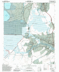
1994 Map of Masontown
USGS Topo · Published 1997About this map
Croatan National Forest dominates this coastal landscape, revealing the complex drainage and wetland systems of eastern North Carolina in the mid-1990s. The northern portion is defined by the Lake Simon Ellis and Little Lake system, where the North Canal, Middle Canal, and South Canal represent significant human alteration of the hydrology to manage the low-lying terrain. To the south, the Pocosin Wilderness preserves a more primitive state of the Millis Swamp and the headwaters of the Newport River. Small settlements like Masontown and Holly Springs occupy the slightly higher ground near the Atlantic and East Carolina railroad corridor, while Newport and Havelock mark the more developed edges of the quadrangle. The map is particularly useful for identifying the specific network of prongs and branches, such as Northwest Prong and Cypress Prong, that feed into the tidal estuary system.
Find a feature on this map
48 named features on this map. Tap any name to fly to it.
Don’t see what you’re looking for? This feature index may not catch every label — zoom into the map to look around manually.
Map Details
Editions of this 1994 Masontown Map
2 editions found
Other maps of this area

1942 · Maysville
USGS Topo · 1:62,500

1942 · Swansboro
USGS Topo · 1:62,500

1948 · Maysville
USGS Topo · 1:62,500

1948 · Swansboro
USGS Topo · 1:62,500

1949 · Havelock
USGS Topo · 1:24,000

1949 · Newport
USGS Topo · 1:24,000

1949 · Salter Path
USGS Topo · 1:24,000

1949 · Mansfield
USGS Topo · 1:24,000

1949 · Cherry Point
USGS Topo · 1:24,000

1949 · Masontown
USGS Topo · 1:24,000