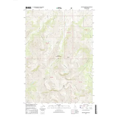
2017 Map of Massacre Mountain
USGS Topo · Published 2017About this map
Massacre Mountain and the high summits of the Last River Range dominate this high-altitude landscape within the Challis National Forest. The map detail reveals a complex network of alpine hydrology, where Auger Lakes and Shadow Lakes sit tucked beneath soaring ridgelines like Castle Peak. This 2017 survey documents the modern drainage patterns of the region, including the headwaters of Dry Creek and Long Lost Creek, as well as the seasonal flow through Hell Canyon. The terrain is marked by remote forest service routes like the Big Creek-Massacre road and the Swauger Lake Spur 1, reflecting a wilderness area managed for conservation and limited backcountry access. The presence of Nolan Lake and several branches of Wet Creek highlights the importance of snowmelt-driven water sources in this part of Idaho's Custer County.
Find a feature on this map
28 named features on this map. Tap any name to fly to it.
Don’t see what you’re looking for? This feature index may not catch every label — zoom into the map to look around manually.
Map Details
Editions of this 2017 Massacre Mountain Map
This is the sole edition of this map. No revisions or reprints were ever made.
Other maps of this area

1935 · MacKay
USGS Topo · 1:96,000

1935 · Borah Peak
USGS Topo · 1:125,000

1938 · Borah Peak
USGS Topo · 1:125,000

1940 · Mackay
USGS Topo · 1:62,500

1955 · Dubois
USGS Topo · 1:250,000

1955 · Idaho Falls
USGS Topo · 1:250,000

1957 · Hawley Mountain
USGS Topo · 1:62,500

1958 · Dubois
USGS Topo · 1:250,000

1958 · Idaho Falls
USGS Topo · 1:250,000

1960 · Mackay
USGS Topo · 1:62,500