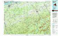
1994 Map of Massena
USGS Topo · Published 1994About this map
The St Lawrence Seaway and St Lawrence River define the northern limit of this landscape, where the international border separates New York from Quebec and Ontario. This region is a complex intersection of water and industry, centered on the industrial hub of Massena and the expansive St Regis Indian Reservation. The industrial legacy of the late twentieth century is visible in the network of Conrail and Canadian National Railways lines that connect border settlements like Rooseveltown and Fort Covington to the interior. Moving south, the terrain rises into the northern reaches of Adirondack Park, where high peaks such as Lyon Mountain and Azure Mountain overlook a series of controlled waters including Rainbow Falls Reservoir and Blake Falls Reservoir. Educational centers like Potsdam State College and Clarkson College anchor the southwestern corner, while the vast Brasher State Forest represents the heavily wooded character of the St. Lawrence and Franklin county borderlands.
Find a feature on this map
173 named features on this map. Tap any name to fly to it.
Don’t see what you’re looking for? This feature index may not catch every label — zoom into the map to look around manually.
Map Details
Editions of this 1994 Massena Map
This is the sole edition of this map. No revisions or reprints were ever made.
Other maps of this area

1896 · Lake Placid
USGS Topo · 1:62,500

1898 · Lake Placid
USGS Topo · 1:62,500

1902 · Saranac
USGS Topo · 1:62,500

1904 · Saranac
USGS Topo · 1:62,500

1905 · Saint Regis
USGS Topo · 1:62,500

1905 · Waddington
USGS Topo · 1:62,500

1906 · Massena
USGS Topo · 1:62,500

1906 · Loon Lake
USGS Topo · 1:62,500

1907 · Massena
USGS Topo · 1:62,500

1908 · Potsdam
USGS Topo · 1:62,500