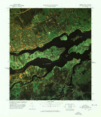
1977 Map of Massena Port of Entry
USGS Topo · Published 1978About this map
The St Lawrence River serves as the focal point for this 1970s infrared color image map, capturing the complex international border zone between New York, Ontario, and Quebec. This aerial perspective highlights the significant infrastructure required for cross-border transit, notably the Seaway International Bridge and the Roosevelt Bridge connecting the United States to Cornwall Island. The imagery provides a distinct view of the river's numerous landforms, from Pilon Island to the appropriately named Graveyard Point near Glen Walter. On the American side, the settlement pattern around Rooseveltown and Hogansburg is clearly defined, showing the proximity of the Massena Port of Entry US Customs to the winding course of the Raquette River and St Regis River. This map is particularly useful for observing the 1970s land use of the St Regis area and the industrial and residential footprint of Cornwall.
Find a feature on this map
36 named features on this map. Tap any name to fly to it.
Don’t see what you’re looking for? This feature index may not catch every label — zoom into the map to look around manually.
Map Details
Editions of this 1977 Massena Port of Entry Map
This is the sole edition of this map. No revisions or reprints were ever made.
Other maps of this area

1906 · Massena
USGS Topo · 1:62,500

1907 · Massena
USGS Topo · 1:62,500

1915 · Moira
USGS Topo · 1:62,500

1917 · Moira
USGS Topo · 1:62,500

1942 · Barnhart Island
USGS Topo · 1:24,000

1943 · Barnhart Island
USGS Topo · 1:31,680

1944 · Moira
USGS Topo · 1:62,500
1946 · Raquette River
USGS Topo · 1:24,000

1948 · Ogdensburg
USGS Topo · 1:250,000

1951 · Ogdensburg
USGS Topo · 1:250,000