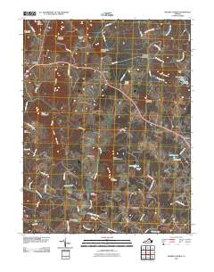
2010 Map of Massies Corner
USGS Topo · Published 2010About this map
The Rappahannock River defines the northeastern boundary of this landscape, where the Piedmont begins its ascent toward the Blue Ridge. Small agricultural settlements and crossroads like Massies Corner, Amissville, and Ben Venue anchor a network of country roads named for local families and landmarks, such as Harry Settle Rd and Thornton River Farm Ln. The topography is marked by significant rises including Battle Mountain, Jefferson Mountain, and Meetinghouse Mountain, which overlook the winding courses of Battle Run and the Thornton River. This 2010 survey reflects a rural character preserved through large holdings like Muskrat Haven Farm and Williams Orchard. Aviation and local industry are represented by the Thornton River Airport and several small dams, including Sweeney Dam and Mosby Dam, which create modest reservoirs such as Sweeney Lake and Lake Mosby tucked between the ridges.
Find a feature on this map
67 named features on this map. Tap any name to fly to it.
Don’t see what you’re looking for? This feature index may not catch every label — zoom into the map to look around manually.
Map Details
Editions of this 2010 Massies Corner Map
This is the sole edition of this map. No revisions or reprints were ever made.
Other maps of this area

1893 · Luray
USGS Topo · 1:125,000

1894 · Warrenton
USGS Topo · 1:125,000

1894 · Warrenton
USGS Topo · 1:62,500

1905 · Luray
USGS Topo · 1:125,000

1927 · Remington
USGS Topo · 1:48,000

1930 · Warrenton
USGS Topo · 1:62,500

1939 · Front Royal
USGS Topo · 1:48,000

1943 · Orlean
USGS Topo · 1:24,000
1944 · Orlean
USGS Topo · 1:31,680

1944 · Front Royal
USGS Topo · 1:62,500