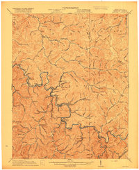
1917 Map of Matewan
USGS Topo · Published 1917About this map
The Tug Fork river defines the border between West Virginia and Kentucky in this 1917 study, where the mountain geography dictated the development of isolated mining and timber settlements. In the southern portion of the quadrangle, the coal economy is evident at the Thacker Mines, while several schools such as Blackberry Fork School and Hatfield School served the families living along the creek bottoms. The map reveals the intricate social fabric of the era through combined post offices and rail stops like Delorme Edgarton PO and Devon Okeeffe PO. Named for the family made famous by local legend, the settlement of Hatfield sits along the southern branch of the river. The topography is characterized by sharp ridges and deep hollows, with named summits like Silk Knob and Dick Knob rising above the winding valley floor settlements of Matewan and Red Jacket.
Find a feature on this map
152 named features on this map. Tap any name to fly to it.
Don’t see what you’re looking for? This feature index may not catch every label — zoom into the map to look around manually.
Map Details
Editions of this 1917 Matewan Map
2 editions found
Other maps of this area

1886 · Grundy
USGS Topo · 1:125,000

1887 · Warfield
USGS Topo · 1:125,000

1890 · Grundy
USGS Topo · 1:125,000

1891 · Tazewell
USGS Topo · 1:125,000

1891 · Oceana
USGS Topo · 1:125,000

1891 · Warfield
USGS Topo · 1:125,000

1892 · Grundy
USGS Topo · 1:125,000

1893 · Oceana
USGS Topo · 1:125,000

1895 · Tazewell
USGS Topo · 1:125,000

1897 · Tazewell
USGS Topo · 1:125,000