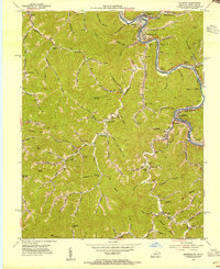
1954 Map of Matewan
USGS Topo · Published 1955About this map
Tug Fork carves a winding path along the state line in the mid-1950s, defining the border between Kentucky and West Virginia where the Norfolk and Western railway snakes through the river valley. The landscape is dotted with small mining and rail-oriented settlements like North Matewan, Delorme (Edgarton P O), and Vulcan. This era shows a transition in the mountains as the terrain is increasingly influenced by industry, with contours in strip mine areas specifically compiled for this survey. Deep in the hollows and along the many branches of Blackberry Creek, local social life is centered around institutions such as Blackberry School and Blue Spring Church. The map details a complex network of small hollows and ridges, from Silk Knob to Calloway Gap, revealing the high density of rural homesteads and family-named landmarks like Hatfield Bottom and Daugherty Bottom that characterize the Tug Valley coal country during this post-war period.
Find a feature on this map
86 named features on this map. Tap any name to fly to it.
Don’t see what you’re looking for? This feature index may not catch every label — zoom into the map to look around manually.
Map Details
Editions of this 1954 Matewan Map
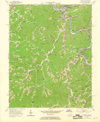
4 editions found
Other maps of this area

1886 · Grundy
USGS Topo · 1:125,000

1887 · Warfield
USGS Topo · 1:125,000

1890 · Grundy
USGS Topo · 1:125,000

1891 · Warfield
USGS Topo · 1:125,000

1892 · Grundy
USGS Topo · 1:125,000

1909 · Matewan
USGS Topo · 1:48,000

1914 · Hurley
USGS Topo · 1:48,000

1915 · Regina
USGS Topo · 1:48,000

1915 · Hurley
USGS Topo · 1:48,000

1915 · Williamson
USGS Topo · 1:48,000