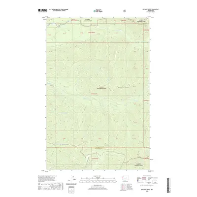
2020 Map of Matheny Ridge
USGS Topo · Published 2020About this map
Matheny Ridge and Sams Ridge define the drainage patterns of this high-elevation landscape in the Pacific Northwest, where the Olympic National Forest meets the southern boundaries of Olympic National Park. The survey illustrates a complex network of waterways, including the Sams River to the north and the upper reaches of the N Fork Salmon River and Middle Fork Salmon River further south. The convergence of these watersheds near the border of Jefferson and Grays Harbor counties highlights the land's transition from federal timber management to protected wilderness. Human activity is largely confined to the Natl Forest Develop Road 2474 Rd, which provides access through the steep terrain toward landmarks such as Higley Peak. Minor tributaries like Matheny Cr, Hook Br, and Dry Cr demonstrate the density of the coastal mountain hydrology.
Find a feature on this map
23 named features on this map. Tap any name to fly to it.
Don’t see what you’re looking for? This feature index may not catch every label — zoom into the map to look around manually.
Map Details
Editions of this 2020 Matheny Ridge Map
This is the sole edition of this map. No revisions or reprints were ever made.
Other maps of this area

1921 · Quinault Lake
USGS Topo · 1:62,500

1943 · Copalis Beach
USGS Topo · 1:250,000

1951 · Copalis Beach
USGS Topo · 1:250,000

1955 · Macafee Hill
USGS Topo · 1:62,500

1955 · Quinault Lake
USGS Topo · 1:62,500

1956 · Kloochman Rock
USGS Topo · 1:62,500

1956 · Salmon River
USGS Topo · 1:62,500

1957 · Copalis Beach
USGS Topo · 1:250,000

1958 · Seattle
USGS Topo · 1:250,000

1962 · Seattle
USGS Topo · 1:250,000