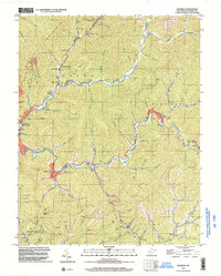
1996 Map of Matheny
USGS Topo · Published 2003About this map
Kopperston and the industrial infrastructure of the Clear Fork valley anchor this mid-1990s West Virginia study. The settlement pattern follows the narrow creek bottoms carved into the highlands of Huff Mountain, where a Compressor Sta and various gas wells indicate the region's energy-based economy. The town of Oceana serves as a primary hub, while smaller communities like Matheny, Edith, and Glen Fork are linked by winding valley roads. Genealogists will find several landmarks of interest, including Hillcrest Memorial Gardens (Cem) and local congregations like Kopperston Ch and Russell Ch. Cultural markers of the era are also present, notably the Drive-In Theater located along the highway between Oceana and Hatcher. The map details a landscape where residential life, such as the Mobile Home Park, sits in close proximity to the steep terrain of Panther Knob and Adkins Gap.
Find a feature on this map
49 named features on this map. Tap any name to fly to it.
Don’t see what you’re looking for? This feature index may not catch every label — zoom into the map to look around manually.
Map Details
Editions of this 1996 Matheny Map
This is the sole edition of this map. No revisions or reprints were ever made.
Other maps of this area

1891 · Oceana
USGS Topo · 1:125,000

1891 · Raleigh
USGS Topo · 1:125,000

1893 · Oceana
USGS Topo · 1:125,000

1897 · Raleigh
USGS Topo · 1:125,000

1898 · Oceana
USGS Topo · 1:125,000

1902 · Raleigh
USGS Topo · 1:125,000

1910 · Pineville
USGS Topo · 1:48,000

1910 · Bald Knob
USGS Topo · 1:48,000

1911 · Marshes
USGS Topo · 1:48,000

1912 · Mullens
USGS Topo · 1:62,500