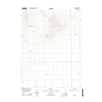
2014 Map of Matlin
USGS Topo · Published 2014About this map
Matlin sits at the center of this 2014 survey of Box Elder County, positioned between the arid elevations of the Matlin Mountains and the lower expanse of the Matlin Basin. The landscape is defined by its water management and grazing infrastructure, highlighted by the Horse Mountain Reservoir to the west. A network of unimproved roads, including Coyote Hill Rd and Flat Rd, provides access across the high desert terrain. Notable topographical landmarks such as Coyote Hill in the northwest and Sheep Mtn in the south serve as primary navigational points in this sparsely populated region of northern Utah. The map clearly delineates the public land survey system boundaries for t10n r13w, showing the rectilinear organization of this remote territory.
Find a feature on this map
13 named features on this map. Tap any name to fly to it.
Don’t see what you’re looking for? This feature index may not catch every label — zoom into the map to look around manually.
Map Details
Editions of this 2014 Matlin Map
This is the sole edition of this map. No revisions or reprints were ever made.
Other maps of this area

1954 · Brigham City
USGS Topo · 1:250,000

1958 · Brigham City
USGS Topo · 1:250,000

1962 · Brigham City
USGS Topo · 1:250,000

1969 · Peplin Flats
USGS Topo · 1:24,000

1969 · Hogup Bar
USGS Topo · 1:24,000

1971 · Red Dome
USGS Topo · 1:24,000

1971 · Matlin
USGS Topo · 1:24,000
1971 · Runswick Wash
USGS Topo · 1:24,000
1971 · Russian Knoll
USGS Topo · 1:24,000

1983 · Terrace Mountain East
USGS Topo · 1:24,000