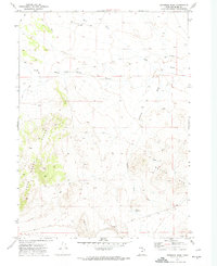
1971 Map of Runswick Wash
USGS Topo · Published 1974About this map
Matlin Mts dominate the southeastern landscape of this high desert terrain in Box Elder County, where the dry drainage of Runswick Wash cuts through the basin toward Cliff Reservoir. The topography recorded during this 1968 photogrammetric survey reveals an arid environment defined by seasonal watercourses like Dove Creek and Warm Spring Wash, with travel across the area limited to a network of Jeep Trails. Local landmarks such as Airplane Hill and Coyote Hill rise from the desert floor, providing vertical relief in a region where mapping was essential for navigating the remote interior of northern Utah. The map captures the land as it existed in the early 1970s, showing the intersection of township and range lines in a largely unsettled expanse of the Great Basin.
Find a feature on this map
13 named features on this map. Tap any name to fly to it.
Don’t see what you’re looking for? This feature index may not catch every label — zoom into the map to look around manually.
Map Details
Editions of this 1971 Runswick Wash Map
2 editions found
Other maps of this area

1954 · Brigham City
USGS Topo · 1:250,000

1958 · Brigham City
USGS Topo · 1:250,000

1959 · Park Valley
USGS Topo · 1:62,500

1959 · Yost
USGS Topo · 1:62,500

1962 · Brigham City
USGS Topo · 1:250,000

1971 · Prohibition Spring
USGS Topo · 1:24,000

1971 · Red Dome
USGS Topo · 1:24,000

1971 · Matlin
USGS Topo · 1:24,000

1971 · Warm Spring Hills
USGS Topo · 1:24,000
1971 · Russian Knoll
USGS Topo · 1:24,000