
1971 Map of Warm Spring Hills
USGS Topo · Published 1974About this map
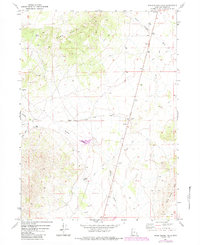
Warm Spring Hills define this high-desert landscape in Box Elder County, where essential water sources dictated the patterns of ranching and movement. The map highlights the central importance of drainage systems like Muddy Creek and Dove Creek, which provide the primary geographic framework for the area. Isolated outposts such as Muddy Ranch appear alongside various watering holes, including Warm Spring, Rhus Spring, and Seep Spring, each vital for livestock in this arid environment. A network of Jeep Trails snakes through the topography, connecting these springs and providing access to several Gravel Pits and a Corral. The intricate detail of the seasonal Birch Cr and Little Birch Cr systems illustrates how the natural topography influenced early 1970s land use and infrastructure in this part of northwestern Utah.
Find a feature on this map
19 named features on this map. Tap any name to fly to it.
Don’t see what you’re looking for? This feature index may not catch every label — zoom into the map to look around manually.
Map Details
Editions of this 1971 Warm Spring Hills Map
2 editions found
Other maps of this area

1954 · Brigham City
USGS Topo · 1:250,000

1958 · Brigham City
USGS Topo · 1:250,000

1959 · Park Valley
USGS Topo · 1:62,500

1959 · Yost
USGS Topo · 1:62,500

1962 · Brigham City
USGS Topo · 1:250,000

1971 · Prohibition Spring
USGS Topo · 1:24,000

1971 · Emigrant Pass
USGS Topo · 1:24,000

1971 · Potters Creek
USGS Topo · 1:24,000

1971 · Red Dome
USGS Topo · 1:24,000
1971 · Runswick Wash
USGS Topo · 1:24,000