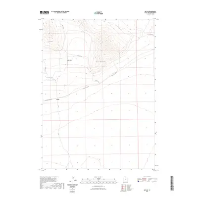
2023 Map of Matlin
USGS Topo · Published 2023About this map
Matlin sits at the junction of several historic transport routes in this high-desert portion of Box Elder County. The landscape is dominated by the Matlin Mountains and the broad Matlin Basin, illustrating the stark basin-and-range topography characteristic of northern Utah. A primary point of interest for those tracking the history of Western transit is the Old Railroad Grade Rd, which traces a significant path through the terrain south of Coyote Hill. This corridor once served as a vital link across the arid plains before being repurposed as a local roadway. Small-scale water management is evident at Horse Mountain Reservoir, reflecting the necessity of irrigation and livestock support in this environment. The map provides a detailed view of the remote road network, including Flat Rd and S Coyote Hill Rd, which connect the scattered topographic landmarks of the region.
Find a feature on this map
11 named features on this map. Tap any name to fly to it.
Don’t see what you’re looking for? This feature index may not catch every label — zoom into the map to look around manually.
Map Details
Editions of this 2023 Matlin Map
This is the sole edition of this map. No revisions or reprints were ever made.
Other maps of this area

1954 · Brigham City
USGS Topo · 1:250,000

1958 · Brigham City
USGS Topo · 1:250,000

1962 · Brigham City
USGS Topo · 1:250,000

1969 · Peplin Flats
USGS Topo · 1:24,000

1969 · Hogup Bar
USGS Topo · 1:24,000

1971 · Red Dome
USGS Topo · 1:24,000

1971 · Matlin
USGS Topo · 1:24,000
1971 · Runswick Wash
USGS Topo · 1:24,000
1971 · Russian Knoll
USGS Topo · 1:24,000

1983 · Terrace Mountain East
USGS Topo · 1:24,000