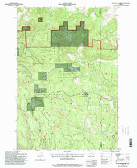
1995 Map of Matlock Prairie
USGS Topo · Published 1998About this map
Umatilla National Forest defines this high-elevation landscape in the mid-1990s, where the boundary between Morrow and Umatilla counties cuts through dense timber and open meadows. The area is characterized by a series of high-altitude grasslands including Matlock Prairie, Balsinger Prairie, and North Prairie, which stand out against the surrounding forest. Central to the map's geography is the Blue Mountain Scenic Byway, which provides access to remote landmarks like the Ellis Forest Service Station and the Fivemile Cow Camp. To the west, Arbuckle Mountain overlooks the drainage of Fivemile Creek. Numerous springs, such as Happy Home Spring and Sulphur Spring, are scattered across the terrain, indicating the vital water sources that supported early seasonal grazing and forestry operations. Historical transit is marked by several named routes including the Turpentine Trail and Freezout Trail.
Find a feature on this map
36 named features on this map. Tap any name to fly to it.
Don’t see what you’re looking for? This feature index may not catch every label — zoom into the map to look around manually.
Map Details
Editions of this 1995 Matlock Prairie Map
This is the sole edition of this map. No revisions or reprints were ever made.
Other maps of this area

1953 · Pendleton
USGS Topo · 1:250,000

1956 · Pendleton
USGS Topo · 1:250,000

1967 · Freezeout Ridge
USGS Topo · 1:24,000

1968 · Hoodlum Canyon
USGS Topo · 1:24,000

1968 · Gurdane
USGS Topo · 1:24,000

1969 · Lake Penland
USGS Topo · 1:24,000

1969 · Sugarbowl Creek
USGS Topo · 1:24,000

1969 · Deerhorn Creek
USGS Topo · 1:24,000

1969 · Thompson Flat
USGS Topo · 1:24,000

1969 · Arbuckle Mtn
USGS Topo · 1:24,000