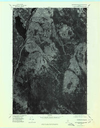
1975 Map of Mattawamkeag NW
USGS Topo · Published 1980About this map
Salmon Stream Lake dominates the northwest corner of this orthophotoquad, reflecting the dense timberland of the Penobscot region during the mid-1970s. This specific aerial perspective, captured in October 1975, reveals the heavy forest canopy and the narrow logging roads or drainage cuts that define the local topography. The landscape is carved by the winding course of Salmon Stream and the lower reach of Wyman Brook, showing the natural drainage patterns of this sparsely populated interior. For researchers or land owners, the map provides a unique visual record of forest density and water levels as they existed prior to modern industrial shifts, serving as a baseline for environmental or property history in this rural Maine quadrangle.
Find a feature on this map
3 named features on this map. Tap any name to fly to it.
Don’t see what you’re looking for? This feature index may not catch every label — zoom into the map to look around manually.
Map Details
Editions of this 1975 Mattawamkeag NW Map
This is the sole edition of this map. No revisions or reprints were ever made.
Other maps of this area

1940 · Sherman
USGS Topo · 1:62,500

1940 · Mattawamkeag
USGS Topo · 1:62,500

1942 · Mattawamkeag
USGS Topo · 1:62,500

1942 · Sherman
USGS Topo · 1:62,500

1951 · Millinocket
USGS Topo · 1:62,500

1953 · Stacyville
USGS Topo · 1:62,500

1954 · Millinocket
USGS Topo · 1:250,000

1958 · Millinocket
USGS Topo · 1:250,000

1960 · Millinocket
USGS Topo · 1:250,000
1975 · Sherman SE
USGS Topo · 1:24,000