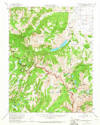
1956 Map of Matterhorn Peak
USGS Topo · Published 1966About this map
Matterhorn Peak stands as the central focal point for this high-altitude survey of the Sierra Nevada, marking the jagged boundary where Yosemite National Park meets the Toiyabe National Forest. The map documents a landscape defined by dramatic geological formations, from the sheer face of The Slide to the numerous alpine basins holding Twin Lakes, Peeler Lake, and Rock Island Lake. Human presence is concentrated in the northeast, where Hunewill Ranch and Mono Village provide glimpses into the region's ranching and early recreation history.
Find a feature on this map
143 named features on this map. Tap any name to fly to it.
Don’t see what you’re looking for? This feature index may not catch every label — zoom into the map to look around manually.
Map Details
Editions of this 1956 Matterhorn Peak Map
4 editions found

Other maps of this area

1896 · Dardanelles
USGS Topo · 1:125,000

1897 · Yosemite
USGS Topo · 1:125,000

1898 · Dardanelles
USGS Topo · 1:125,000

1900 · Yosemite
USGS Topo · 1:125,000

1901 · Mt. Lyell
USGS Topo · 1:125,000

1903 · Yosemite
USGS Topo · 1:125,000

1909 · Yosemite
USGS Topo · 1:125,000

1909 · Bridgeport
USGS Topo · 1:125,000

1911 · Bridgeport
USGS Topo · 1:125,000

1920 · Bridgeport
USGS Topo · 1:125,000