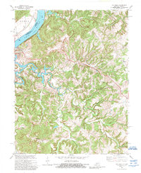
1970 Map of Mattingly
USGS Topo · Published 1989About this map
The Ohio River forms the natural boundary between Indiana and Kentucky in this survey, where the river narrows between Mile 708 and Mile 710. On the Kentucky side, the settlement of Cloverport sits at the mouth of Clover Creek, serving as a focal point for the region's river-based transport and inland development. The interior landscape is defined by the winding paths of Hites Run, Tar Fork, and Springlick Branch, creating a complex network of valleys and ridges including Ska Pouch Hill.
Find a feature on this map
35 named features on this map. Tap any name to fly to it.
Don’t see what you’re looking for? This feature index may not catch every label — zoom into the map to look around manually.
Map Details
Editions of this 1970 Mattingly Map
2 editions found
Other maps of this area

1928 · Hardinsburg
USGS Topo · 1:48,000

1931 · Hardinsburg
USGS Topo · 1:62,500

1932 · Fordsville
USGS Topo · 1:62,500

1934 · Cannelton
USGS Topo · 1:62,500

1947 · Lodiburg
USGS Topo · 1:24,000

1947 · Hardinsburg
USGS Topo · 1:24,000

1947 · Hardinsburg
USGS Topo · 1:62,500

1949 · Cannelton
USGS Topo · 1:24,000

1953 · Cannelton
USGS Topo · 1:24,000

1953 · Hardinsburg
USGS Topo · 1:24,000