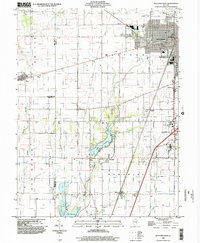
1998 Map of Mattoon West
USGS Topo · Published 2002About this map
The Mattoon municipal landscape and its surrounding rural townships dominate this late-twentieth-century study, where industrial and educational infrastructure meet the central Illinois prairie. The northeastern quadrant is defined by the city's expansion, including the Water Treatment Plant and the campus of Lake Land Jr College. These developed areas contrast with the hydraulic network of the Little Wabash River and its tributaries, which feed into significant local reservoirs like Paradise Lake and Lake Mattoon.
Find a feature on this map
29 named features on this map. Tap any name to fly to it.
Don’t see what you’re looking for? This feature index may not catch every label — zoom into the map to look around manually.
Map Details
Editions of this 1998 Mattoon West Map
This is the sole edition of this map. No revisions or reprints were ever made.
Other maps of this area

1934 · Mattoon
USGS Topo · 1:62,500

1935 · Arcola
USGS Topo · 1:48,000

1935 · Sullivan
USGS Topo · 1:48,000

1937 · Mattoon
USGS Topo · 1:62,500

1940 · Sullivan
USGS Topo · 1:62,500

1940 · Arcola
USGS Topo · 1:62,500

1947 · Stewardson
USGS Topo · 1:62,500

1949 · Stewardson
USGS Topo · 1:62,500

1958 · Decatur
USGS Topo · 1:250,000

1961 · Decatur
USGS Topo · 1:250,000