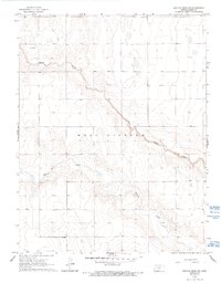
1965 Map of Mattox Draw NW
USGS Topo · Published 1993About this map
West Hibbard defines the landscape of this Kearny County region, where the high plains are carved by the intricate drainage networks of James Draw and Mattox Draw. The topography, based on 1964 aerial photography and 1965 field checking, reveals a sparsely populated agricultural environment dominated by section-line tracks and natural contours. Local history and genealogy interest is anchored by Fairview Cem in the northern portion of the map, serving as a primary landmark for researchers. Evidence of early subsurface exploration or resource management appears through labels for a Drill Hole and a Well, indicating the infrastructure necessary for life and industry in this part of Kansas. The map captures the area just before significant modernization, showing a land still defined by its original survey lines and intermittent watercourses.
Find a feature on this map
7 named features on this map. Tap any name to fly to it.
Don’t see what you’re looking for? This feature index may not catch every label — zoom into the map to look around manually.
Map Details
Editions of this 1965 Mattox Draw NW Map
2 editions found
Other maps of this area

1955 · Scott City
USGS Topo · 1:250,000

1958 · Scott City
USGS Topo · 1:250,000

1965 · Leoti 3 NW
USGS Topo · 1:24,000

1965 · Leoti 3 NE
USGS Topo · 1:24,000
1966 · Leoti 3 SW
USGS Topo · 1:24,000
1966 · Tribune 4 SE
USGS Topo · 1:24,000

1966 · Tribune 4 NE
USGS Topo · 1:24,000
1966 · Leoti 3 SE
USGS Topo · 1:24,000

1970 · Selkirk SE
USGS Topo · 1:24,000

1970 · Lydia
USGS Topo · 1:24,000