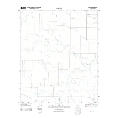
2012 Map of Mattson
USGS Topo · Published 2012About this map
Mattson anchors the southern portion of this Haskell County landscape, characterized by the winding drainage systems of Millers Cr and its tributaries. The terrain is defined by its rural road network, where legacy thoroughfares like Chamberlan Rd and Ranch Rd 1080 connect isolated homesteads and agricultural tracts. A significant local landmark for genealogists is the Brushy Cem, situated near Brushy Cr in the northeastern quadrant, providing a focal point for tracing family histories in the area. The water geography is dominated by intermittent streams and local stock ponds, including Elm Cr Tank near the small settlement of West Camp. These features illustrate the vital role of water management in this part of Texas, where the courses of Lake Cr and Wild Horse Cr dictate the layout of property lines and grazing lands.
Find a feature on this map
31 named features on this map. Tap any name to fly to it.
Don’t see what you’re looking for? This feature index may not catch every label — zoom into the map to look around manually.
Map Details
Editions of this 2012 Mattson Map
This is the sole edition of this map. No revisions or reprints were ever made.
Other maps of this area

1954 · Wichita Falls
USGS Topo · 1:250,000

1958 · Wichita Falls
USGS Topo · 1:250,000

1962 · Antelope Creek SW
USGS Topo · 1:24,000

1962 · Antelope Creek NW
USGS Topo · 1:24,000

1965 · Reynolds Bend NW
USGS Topo · 1:24,000

1966 · Haskell
USGS Topo · 1:24,000
1966 · Irby
USGS Topo · 1:24,000

1967 · Weinert
USGS Topo · 1:24,000

1967 · Mattson
USGS Topo · 1:24,000

1968 · Munday West
USGS Topo · 1:24,000