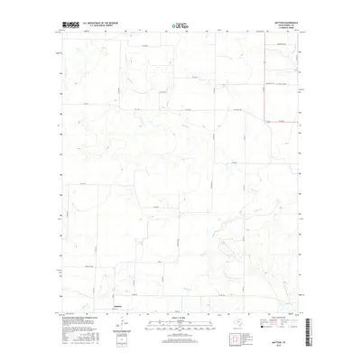
2016 Map of Mattson
USGS Topo · Published 2016About this map
Mattson and the rural stretches of Haskell County are defined by a network of drainage systems and farm-to-market roads in this mid-2010s survey. The landscape is primarily shaped by the meandering courses of Brushy Cr, Millers Cr, and Lake Cr, which carve through the terrain and dictate the placement of ranching infrastructure. A notable local landmark is Brushy Cem, located in the northeastern quadrant near the H C (Pick) Yandell area.
Find a feature on this map
30 named features on this map. Tap any name to fly to it.
Don’t see what you’re looking for? This feature index may not catch every label — zoom into the map to look around manually.
Map Details
Editions of this 2016 Mattson Map
This is the sole edition of this map. No revisions or reprints were ever made.
Other maps of this area

1954 · Wichita Falls
USGS Topo · 1:250,000

1958 · Wichita Falls
USGS Topo · 1:250,000

1962 · Antelope Creek SW
USGS Topo · 1:24,000

1962 · Antelope Creek NW
USGS Topo · 1:24,000

1965 · Reynolds Bend NW
USGS Topo · 1:24,000

1966 · Haskell
USGS Topo · 1:24,000
1966 · Irby
USGS Topo · 1:24,000

1967 · Weinert
USGS Topo · 1:24,000

1967 · Mattson
USGS Topo · 1:24,000

1968 · Munday West
USGS Topo · 1:24,000