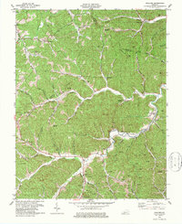
1979 Map of Maulden
USGS Topo · Published 1979About this map
Burning Springs serves as a primary southern anchor for this section of Clay County, situated where Brushy Branch and Sacker Creek meet the winding Sexton Creek. The landscape in 1979 is defined by a dense network of mountain hollows and branches, where family names are etched into the geography through landmarks like Reynolds Cem, Pennington Cem, and Boggs Flat Cems. Small rural settlements like Maulden and Island City are connected by narrow roads following the valley floors, while the higher ridges show the expanding footprint of the energy industry.
Find a feature on this map
73 named features on this map. Tap any name to fly to it.
Don’t see what you’re looking for? This feature index may not catch every label — zoom into the map to look around manually.
Map Details
Editions of this 1979 Maulden Map
This is the sole edition of this map. No revisions or reprints were ever made.
Other maps of this area

1891 · Manchester
USGS Topo · 1:125,000

1952 · Portersburg
USGS Topo · 1:24,000

1952 · Manchester
USGS Topo · 1:24,000

1953 · Mc Kee
USGS Topo · 1:24,000

1953 · Oneida
USGS Topo · 1:24,000

1953 · Tyner
USGS Topo · 1:24,000

1953 · Booneville
USGS Topo · 1:24,000

1953 · Sturgeon
USGS Topo · 1:24,000

1954 · Barcreek
USGS Topo · 1:24,000

1954 · Maulden
USGS Topo · 1:24,000