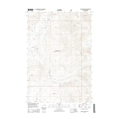
2014 Map of Maurice Mountain
USGS Topo · Published 2014About this map
Maurice Mtn and the surrounding high country of the Beaverhead National Forest dominate this landscape in Beaverhead County. The terrain is defined by a dense network of drainages, including the Wise River, Gold Cr, and Elk Cr, which flow through deep timber and high meadows. For those researching local history, the Maurice Cem is a notable point of interest north of Maurice Pond. Transportation through this corner of the Pioneer Mountains is facilitated by the Pioneer Mountains Scenic Byway, which follows the river valley. The southern portion of the map includes Mono Park and Moose Park, while high-altitude water bodies like Lake Abundance and Crescent Lake sit tucked below the eastern ridges. Indications of the area's industrial past are preserved in road names such as Coolidge Mine Rd.
Find a feature on this map
36 named features on this map. Tap any name to fly to it.
Don’t see what you’re looking for? This feature index may not catch every label — zoom into the map to look around manually.
Map Details
Editions of this 2014 Maurice Mountain Map
This is the sole edition of this map. No revisions or reprints were ever made.
Other maps of this area

1893 · Dillon
USGS Topo · 1:250,000

1952 · Torrey Mountain
USGS Topo · 1:24,000

1955 · Dillon
USGS Topo · 1:250,000

1957 · Dillon
USGS Topo · 1:250,000

1958 · Dillon
USGS Topo · 1:250,000

1958 · Vipond Park
USGS Topo · 1:62,500

1959 · Polaris
USGS Topo · 1:62,500

1962 · Dillon
USGS Topo · 1:250,000

1965 · Dillon
USGS Topo · 1:250,000
1975 · Butte South
USGS Topo · 1:100,000