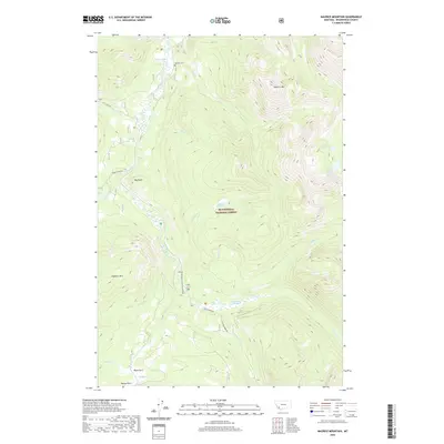
2020 Map of Maurice Mountain
USGS Topo · Published 2020About this map
Beaverhead National Forest defines the high-altitude landscape of this Montana quadrangle, where the Wise River flows northward through a complex of mountain peaks and alpine meadows. The terrain is marked by significant elevations like Maurice Mtn and Seymore Mtn, with local history anchored at the Maurice Cem near the northern border. A network of early access routes and high-mountain paths includes the Pioneer Mountains Scenic Byway, which parallels the river, and the Coolidge Mine Rd branching into the eastern slopes. Distinctive natural openings in the dense timber, such as Jacobson Meadows and Little Joe Meadows, appear alongside water bodies like Lake Abundance and Crescent Lake. These high-country features, along with open areas at Mono Park and Moose Park, suggest a landscape shaped by seasonal grazing and historical mining access.
Find a feature on this map
38 named features on this map. Tap any name to fly to it.
Don’t see what you’re looking for? This feature index may not catch every label — zoom into the map to look around manually.
Map Details
Editions of this 2020 Maurice Mountain Map
This is the sole edition of this map. No revisions or reprints were ever made.
Other maps of this area

1893 · Dillon
USGS Topo · 1:250,000

1952 · Torrey Mountain
USGS Topo · 1:24,000

1955 · Dillon
USGS Topo · 1:250,000

1957 · Dillon
USGS Topo · 1:250,000

1958 · Dillon
USGS Topo · 1:250,000

1958 · Vipond Park
USGS Topo · 1:62,500

1959 · Polaris
USGS Topo · 1:62,500

1962 · Dillon
USGS Topo · 1:250,000

1965 · Dillon
USGS Topo · 1:250,000
1975 · Butte South
USGS Topo · 1:100,000