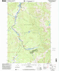
1997 Map of Maurice Mountain
USGS Topo · Published 2001About this map
Beaverhead National Forest defines this high-elevation landscape, where the Pioneer River carves a central valley between Seymore Mountain and the peaks of Maurice Mountain. The mapping reveals a late 20th-century landscape managed for recreation and resource extraction, punctuated by the Little Joe Campground and the Mono Creek Campground. A small Mine and several gravel pits indicate the area's geological utility, while the Maurice Cem near Maurice Pond provides a specific point of interest for local genealogical research.
Find a feature on this map
37 named features on this map. Tap any name to fly to it.
Don’t see what you’re looking for? This feature index may not catch every label — zoom into the map to look around manually.
Map Details
Editions of this 1997 Maurice Mountain Map
This is the sole edition of this map. No revisions or reprints were ever made.
Other maps of this area

1893 · Dillon
USGS Topo · 1:250,000

1952 · Torrey Mountain
USGS Topo · 1:24,000

1955 · Dillon
USGS Topo · 1:250,000

1957 · Dillon
USGS Topo · 1:250,000

1958 · Dillon
USGS Topo · 1:250,000

1958 · Vipond Park
USGS Topo · 1:62,500

1959 · Polaris
USGS Topo · 1:62,500

1962 · Dillon
USGS Topo · 1:250,000

1965 · Dillon
USGS Topo · 1:250,000
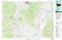
1975 · Butte South
USGS Topo · 1:100,000