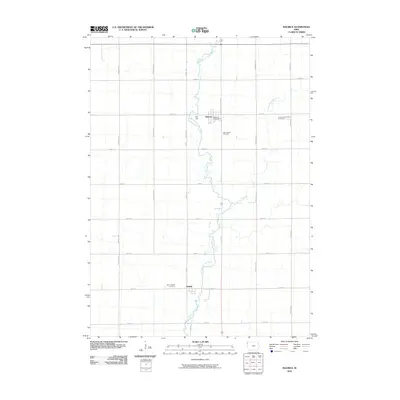
2010 Map of Maurice
USGS Topo · Published 2010About this map
West Branch Floyd River meanders south through this corner of Sioux County, Iowa, defining the drainage patterns and local geography of the region. The map centers on Maurice, where the Maurice Post Office and Saint Marys Cemetery serve as focal points for the local community. Further south, the settlement of Struble sits near the Saint Joseph Cemetery, illustrating the linear settlement patterns typical of the Iowa prairie. The landscape is structured by a rigorous grid of section-line roads, including Hickory Ave and 470th ST, which intersect the occasional curves of the Orange City Slough. This survey captures the rural character of the area in the early 21st century, dominated by agricultural land use and small townships like those represented by the Sherman Township Cemetery.
Find a feature on this map
25 named features on this map. Tap any name to fly to it.
Don’t see what you’re looking for? This feature index may not catch every label — zoom into the map to look around manually.
Map Details
Editions of this 2010 Maurice Map
This is the sole edition of this map. No revisions or reprints were ever made.
Other maps of this area

1955 · Sioux City
USGS Topo · 1:250,000

1955 · Sioux Falls
USGS Topo · 1:250,000

1958 · Sioux City
USGS Topo · 1:250,000

1958 · Sioux Falls
USGS Topo · 1:250,000

1959 · Sioux City
USGS Topo · 1:250,000

1962 · Le Mars
USGS Topo · 1:62,500

1964 · Orange City
USGS Topo · 1:24,000

1964 · Sioux Center
USGS Topo · 1:24,000

1968 · Labanon
USGS Topo · 1:24,000
1969 · Ireton
USGS Topo · 1:24,000