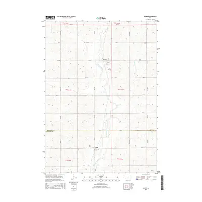
2015 Map of Maurice
USGS Topo · Published 2015About this map
The town of Maurice sits at the heart of this agricultural landscape in Sioux County, where the West Branch Floyd River carves a path southward toward the Plymouth County line. The settlement of Struble marks the southern reach of the survey, anchored by Saint Joseph Cemetery along the West Branch Floyd River. The geography is defined by a dense grid of section roads including Garfield Avenue and Hickory Avenue, connecting isolated farmsteads with local landmarks such as Saint Marys Cemetery and Sherman Township Cemetery. This survey illustrates the persistent rural character of Northwest Iowa in the early 21st century, showing how the drainage patterns of the Orange City Slough and other small tributaries have influenced the placement of both roads and historic burial grounds.
Find a feature on this map
38 named features on this map. Tap any name to fly to it.
Don’t see what you’re looking for? This feature index may not catch every label — zoom into the map to look around manually.
Map Details
Editions of this 2015 Maurice Map
This is the sole edition of this map. No revisions or reprints were ever made.
Other maps of this area

1955 · Sioux City
USGS Topo · 1:250,000

1955 · Sioux Falls
USGS Topo · 1:250,000

1958 · Sioux City
USGS Topo · 1:250,000

1958 · Sioux Falls
USGS Topo · 1:250,000

1959 · Sioux City
USGS Topo · 1:250,000

1962 · Le Mars
USGS Topo · 1:62,500

1964 · Orange City
USGS Topo · 1:24,000

1964 · Sioux Center
USGS Topo · 1:24,000

1968 · Labanon
USGS Topo · 1:24,000
1969 · Ireton
USGS Topo · 1:24,000