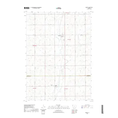
2018 Map of Maurice
USGS Topo · Published 2018About this map
The agrarian borderlands of northwest Iowa are meticulously charted here, centered on the communities of Maurice in Sioux County and Struble to the south in Plymouth County. The landscape is defined by the winding course of the West Branch Floyd River and its tributary, the Orange City Slough, which drain the surrounding agricultural tracts. This 2018 survey reveals a highly organized section-line road network, including thoroughfares like Co Rd B58 and Co Rd C12, which link the farmsteads to these small rail-era settlements. Genealogists will find particular value in the clearly marked locations of Saint Marys Cem, Sherman Township Cem, and Saint Joseph Cem, which serve as vital records of the area's local history and heritage across the Sioux Co and Plymouth Co line.
Find a feature on this map
38 named features on this map. Tap any name to fly to it.
Don’t see what you’re looking for? This feature index may not catch every label — zoom into the map to look around manually.
Map Details
Editions of this 2018 Maurice Map
This is the sole edition of this map. No revisions or reprints were ever made.
Other maps of this area

1955 · Sioux City
USGS Topo · 1:250,000

1955 · Sioux Falls
USGS Topo · 1:250,000

1958 · Sioux City
USGS Topo · 1:250,000

1958 · Sioux Falls
USGS Topo · 1:250,000

1959 · Sioux City
USGS Topo · 1:250,000

1962 · Le Mars
USGS Topo · 1:62,500

1964 · Orange City
USGS Topo · 1:24,000

1964 · Sioux Center
USGS Topo · 1:24,000

1968 · Labanon
USGS Topo · 1:24,000
1969 · Ireton
USGS Topo · 1:24,000