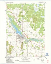
1983 Map of Mauston
USGS Topo · Published 1984About this map
The Lemonweir River winds through the heart of the central Wisconsin landscape, widening into Decorah Lake just as it passes the city of Mauston. In the early 1980s, this area reflects a stable community structured around the Chicago Milwaukee St Paul and Pacific railroad and a grid of rural roads like Welch Prairie Road and Suldal Road. The topography is defined by the sudden rise of Cambrian sandstone outliers such as Smarts Bluff, Prices Bluff, and Townline Bluff, which punctuate the otherwise level river valley.
Find a feature on this map
67 named features on this map. Tap any name to fly to it.
Don’t see what you’re looking for? This feature index may not catch every label — zoom into the map to look around manually.
Map Details
Editions of this 1983 Mauston Map
This is the sole edition of this map. No revisions or reprints were ever made.
Other maps of this area

1901 · The Dells
USGS Topo · 1:62,500

1921 · Mauston
USGS Topo · 1:62,500

1956 · Reedsburg
USGS Topo · 1:62,500

1957 · Wisconsin Dells
USGS Topo · 1:62,500

1957 · Madison
USGS Topo · 1:250,000

1958 · La Crosse
USGS Topo · 1:250,000

1960 · Madison
USGS Topo · 1:250,000

1961 · La Crosse
USGS Topo · 1:250,000

1961 · Adams
USGS Topo · 1:62,500

1962 · Mauston
USGS Topo · 1:62,500