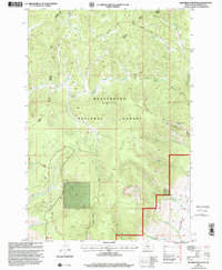
1997 Map of Maverick Mountain
USGS Topo · Published 2001About this map
Beaverhead Mountain serves as a prominent landmark within the Beaverhead National Forest, dominating a landscape defined by the drainage systems of the Big Hole Divide. This 1990s revision of earlier 1950s topography shows the transition between the high peaks and the lower Grasshopper Valley, where Grasshopper Creek flows south toward the Pioneer Mountains. The survey details a network of mountain trails and secondary routes such as the Wisdom Wise River Rd, providing access to remote timber and recreational areas including the Maverick Mountain Ski Area. Named water features like Bear Wallow Creek, Shoestring Creek, and Kunselman Creek trace the intricate hydrology of the area, reflecting a region where water rights and alpine access remained critical to local land use at the close of the twentieth century.
Find a feature on this map
29 named features on this map. Tap any name to fly to it.
Don’t see what you’re looking for? This feature index may not catch every label — zoom into the map to look around manually.
Map Details
Editions of this 1997 Maverick Mountain Map
This is the sole edition of this map. No revisions or reprints were ever made.
Other maps of this area

1955 · Dillon
USGS Topo · 1:250,000

1957 · Dillon
USGS Topo · 1:250,000

1958 · Dillon
USGS Topo · 1:250,000

1959 · Polaris
USGS Topo · 1:62,500

1962 · Dillon
USGS Topo · 1:250,000

1962 · Stewart Mountain
USGS Topo · 1:24,000

1965 · Dillon
USGS Topo · 1:250,000
1978 · Odell Lake
USGS Topo · 1:24,000
1978 · Maurice Mountain
USGS Topo · 1:24,000

1978 · Butch Hill
USGS Topo · 1:24,000