1973 Map of Mavie
USGS Topo · Published 1976About this map
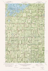
Elm Lake and the surrounding Wildlife Management Area dominate the northern landscape of this Northwestern Minnesota quadrangle, where the expansive Grand Plain meets a complex network of man-made drainage systems. The survey highlights a highly organized agricultural grid defined by features like County Ditch No 27 and Judicial Ditch No 18, which were essential for managing the low-lying terrain. Human history is etched into the land through the Old Indian Treaty Bdy and the Old Railroad Grade passing through the small settlement of Mavie. Local genealogical points of interest include the Germantown Cem and a central Townhall, reflecting the civic and social structure of the rural community during the early 1970s.
Find a feature on this map
14 named features on this map. Tap any name to fly to it.
Don’t see what you’re looking for? This feature index may not catch every label — zoom into the map to look around manually.
Map Details
Editions of this 1973 Mavie Map
This is the sole edition of this map. No revisions or reprints were ever made.
Other maps of this area

1918 · Rollis
USGS Topo · 1:62,500
1918 · Middle River
USGS Topo · 1:62,500

1943 · Rollis
USGS Topo · 1:62,500
1943 · Thief River Falls
USGS Topo · 1:62,500

1952 · Thief River Falls
USGS Topo · 1:250,000

1954 · Roseau
USGS Topo · 1:250,000

1956 · Thief River Falls
USGS Topo · 1:250,000

1957 · Roseau
USGS Topo · 1:250,000

1957 · Thief River Falls
USGS Topo · 1:250,000

1958 · Roseau
USGS Topo · 1:250,000