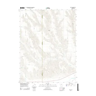
2014 Map of Max NE
USGS Topo · Published 2014About this map
The boundary between Dundy and Hitchcock counties bisects this High Plains landscape, where the terrain is defined by deeply etched drainage systems feeding toward the southern river valley. In the north, the Ash Grove Cemetery sits near Avenue 347, serving as a quiet landmark of early regional settlement. The map reveals the intricate network of watercourses that have carved the land, including the winding paths of E Muddy Cr, Spring Br, and Muddy Cr. Significant geological features like Milken Canyon and Hay Canyon show the erosion patterns characteristic of this part of Nebraska. In the south, the landscape transitions to the Republican River basin, accompanied by Indian Cr and the Gardner Reservoir, illustrating the vital relationship between water management and the agricultural road grid.
Find a feature on this map
21 named features on this map. Tap any name to fly to it.
Don’t see what you’re looking for? This feature index may not catch every label — zoom into the map to look around manually.
Map Details
Editions of this 2014 Max NE Map
This is the sole edition of this map. No revisions or reprints were ever made.
Other maps of this area

1954 · McCook
USGS Topo · 1:250,000

1957 · McCook
USGS Topo · 1:250,000

1958 · McCook
USGS Topo · 1:250,000

1962 · Trenton SW
USGS Topo · 1:24,000
1962 · Max SE
USGS Topo · 1:24,000

1962 · Stratton
USGS Topo · 1:24,000

1962 · Max NE
USGS Topo · 1:24,000
1962 · Max
USGS Topo · 1:24,000

1973 · Wauneta SW
USGS Topo · 1:24,000
1973 · Rock Canyon
USGS Topo · 1:24,000