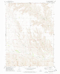
1973 Map of Rock Canyon
USGS Topo · Published 1977About this map
Muddy Creek and the deep drainage of Rock Canyon define the landscape of Dundy County in this mid-1970s survey. The terrain is a network of sharp erosional features including Kelly Gulch and several deep canyons in the south, such as Hickman Can, Blackwater Can, and Cheyenne Can. Human presence is sparse and largely focused on water access and infrastructure, evidenced by scattered Well sites and a prominent Pipeline cutting through the southern sections. For local history, the Highland Cem stands as a primary landmark of the early community, while the Howard BM 3130 provides a specific reference point for surveyors. The confluence of the North Branch Indian Creek and Indian Creek shows the natural drainage patterns that have historically shaped ranching and movement through this part of the Nebraska plains.
Find a feature on this map
14 named features on this map. Tap any name to fly to it.
Don’t see what you’re looking for? This feature index may not catch every label — zoom into the map to look around manually.
Map Details
Editions of this 1973 Rock Canyon Map
This is the sole edition of this map. No revisions or reprints were ever made.
Other maps of this area

1954 · McCook
USGS Topo · 1:250,000

1957 · McCook
USGS Topo · 1:250,000

1958 · McCook
USGS Topo · 1:250,000

1961 · Benkelman
USGS Topo · 1:24,000
1962 · Max SE
USGS Topo · 1:24,000

1962 · Max NE
USGS Topo · 1:24,000
1962 · Max
USGS Topo · 1:24,000

1973 · Ough
USGS Topo · 1:24,000

1973 · Wauneta SW
USGS Topo · 1:24,000

1973 · Wauneta SE
USGS Topo · 1:24,000