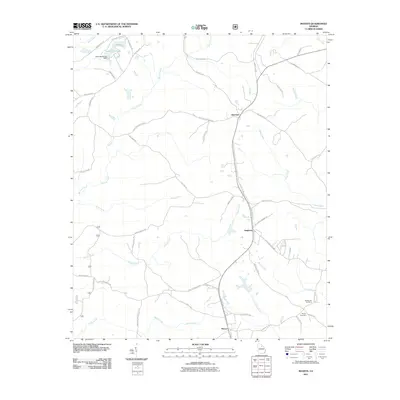
2011 Map of Maxeys
USGS Topo · Published 2011About this map
Maxeys and Stephens anchor this Oglethorpe County landscape, where the rural character of Georgia is defined by a dense network of local roads and creek drainages. The area is marked by family-named landmarks and historical infrastructure, including Railroad Rd following a former rail alignment through the heart of the quadrangle. Significant water features such as Lake Oglethorpe and its associated Lake Oglethorpe Dam sit in the north, while the North Fork Little River and Sandy Creek drain the southern reaches. For those researching local lineages, the presence of the McWhorter Cemetery and Moody Cemetery near the crossroads of McWhorter Rd offers specific points of interest. The map also captures several old thoroughfares like Arnolds Mill Rd and Faust Farm Rd, suggesting the historical agricultural and milling foundations of these small communities.
Find a feature on this map
57 named features on this map. Tap any name to fly to it.
Don’t see what you’re looking for? This feature index may not catch every label — zoom into the map to look around manually.
Map Details
Editions of this 2011 Maxeys Map
This is the sole edition of this map. No revisions or reprints were ever made.
Other maps of this area

1953 · Athens
USGS Topo · 1:250,000

1958 · Athens
USGS Topo · 1:250,000

1959 · Athens
USGS Topo · 1:250,000

1963 · Athens
USGS Topo · 1:250,000

1964 · Barnett Shoals
USGS Topo · 1:24,000
1964 · Athens East
USGS Topo · 1:24,000

1965 · Woodville
USGS Topo · 1:24,000
1971 · Sandy Cross
USGS Topo · 1:24,000
1971 · Crawford
USGS Topo · 1:24,000

1971 · Maxeys
USGS Topo · 1:24,000